You are here: Home > Network List > G - GEOSCOPE Stations List
> Station WUS Wushi, Xinjiang Uygur, China > Earthquake Result Viewer
WUS Wushi, Xinjiang Uygur, China - Earthquake Result Viewer

| Earthquake location: |
Kuril Islands |
| Earthquake latitude/longitude: |
44.5/149.4 |
| Earthquake time(UTC): |
1996/01/31 (031) 20:30:47 GMT |
| Earthquake Depth: |
58 km |
| Earthquake Magnitude: |
5.8 MB, 6.1 UNKNOWN, 5.9 MW |
| Earthquake Catalog/Contributor: |
WHDF/NEIC |
|
| Network: |
G GEOSCOPE |
| Station: |
WUS Wushi, Xinjiang Uygur, China |
| Lat/Lon: |
41.20 N/79.22 E |
| Elevation: |
1457 m |
|
| Distance: |
50.1 deg |
| Az: |
292.3 deg |
| Baz: |
61.408 deg |
| Ray Param: |
0.06812015 |
| Estimated Moho Depth: |
58.75 km |
| Estimated Crust Vp/Vs: |
1.67 |
| Assumed Crust Vp: |
6.353 km/s |
| Estimated Crust Vs: |
3.804 km/s |
| Estimated Crust Poisson's Ratio: |
0.22 |
|
| Radial Match: |
94.69857 % |
| Radial Bump: |
400 |
| Transverse Match: |
88.90557 % |
| Transverse Bump: |
400 |
| SOD ConfigId: |
6273 |
| Insert Time: |
2010-02-27 00:56:02.857 +0000 |
| GWidth: |
2.5 |
| Max Bumps: |
400 |
| Tol: |
0.001 |
|
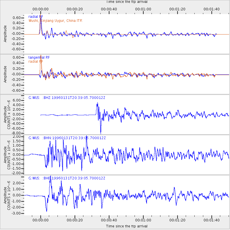
Signal To Noise
| Channel | StoN | STA | LTA |
| G:WUS: :BHN:19960131T20:39:05.700012Z | 5.6709194 | 5.4696335E-7 | 9.645056E-8 |
| G:WUS: :BHE:19960131T20:39:05.700012Z | 12.513633 | 8.701368E-7 | 6.9535105E-8 |
| G:WUS: :BHZ:19960131T20:39:05.700012Z | 18.245811 | 1.8877923E-6 | 1.0346442E-7 |
| Arrivals |
| Ps | 6.6 SECOND |
| PpPs | 23 SECOND |
| PsPs/PpSs | 30 SECOND |


