You are here: Home > Network List > G - GEOSCOPE Stations List
> Station WUS Wushi, Xinjiang Uygur, China > Earthquake Result Viewer
WUS Wushi, Xinjiang Uygur, China - Earthquake Result Viewer

| Earthquake location: |
Minahassa Peninsula, Sulawesi |
| Earthquake latitude/longitude: |
1.0/120.2 |
| Earthquake time(UTC): |
1996/02/07 (038) 07:57:20 GMT |
| Earthquake Depth: |
33 km |
| Earthquake Magnitude: |
5.5 MB, 5.6 MS, 6.1 UNKNOWN, 5.9 MW |
| Earthquake Catalog/Contributor: |
WHDF/NEIC |
|
| Network: |
G GEOSCOPE |
| Station: |
WUS Wushi, Xinjiang Uygur, China |
| Lat/Lon: |
41.20 N/79.22 E |
| Elevation: |
1457 m |
|
| Distance: |
54.5 deg |
| Az: |
322.55 deg |
| Baz: |
126.323 deg |
| Ray Param: |
0.06533844 |
| Estimated Moho Depth: |
57.0 km |
| Estimated Crust Vp/Vs: |
1.63 |
| Assumed Crust Vp: |
6.353 km/s |
| Estimated Crust Vs: |
3.898 km/s |
| Estimated Crust Poisson's Ratio: |
0.20 |
|
| Radial Match: |
93.78006 % |
| Radial Bump: |
400 |
| Transverse Match: |
77.594185 % |
| Transverse Bump: |
400 |
| SOD ConfigId: |
6273 |
| Insert Time: |
2010-02-27 00:56:04.035 +0000 |
| GWidth: |
2.5 |
| Max Bumps: |
400 |
| Tol: |
0.001 |
|
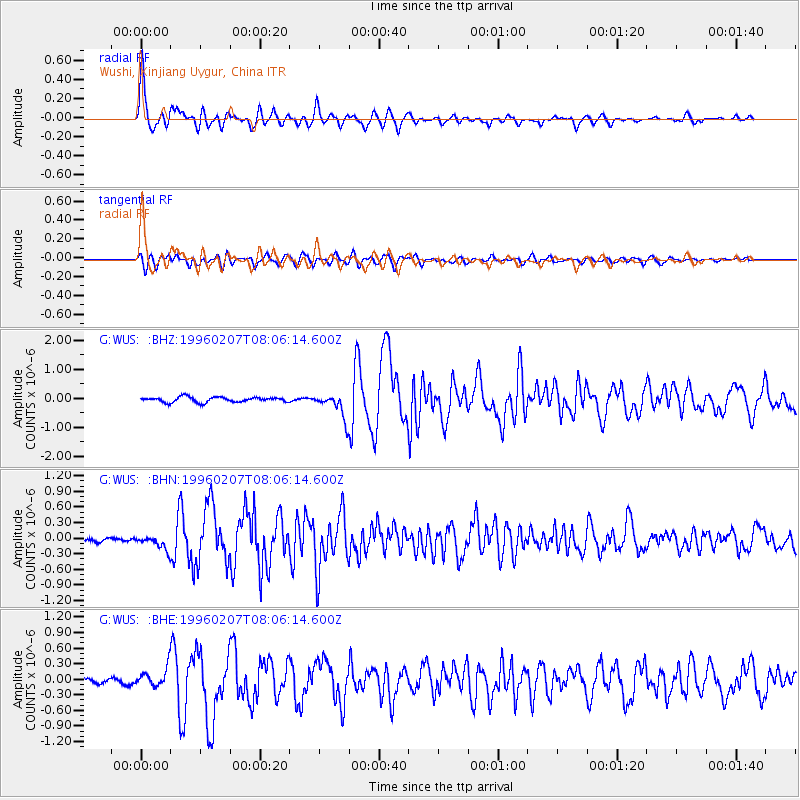
Signal To Noise
| Channel | StoN | STA | LTA |
| G:WUS: :BHN:19960207T08:06:14.600Z | 3.4042144 | 1.4570945E-7 | 4.2802668E-8 |
| G:WUS: :BHE:19960207T08:06:14.600Z | 2.454095 | 1.9485088E-7 | 7.939826E-8 |
| G:WUS: :BHZ:19960207T08:06:14.600Z | 4.795299 | 4.3134415E-7 | 8.9951456E-8 |
| Arrivals |
| Ps | 6.0 SECOND |
| PpPs | 22 SECOND |
| PsPs/PpSs | 28 SECOND |


