You are here: Home > Network List > TA - USArray Transportable Network (new EarthScope stations) Stations List
> Station U46A Springville, TN, USA > Earthquake Result Viewer
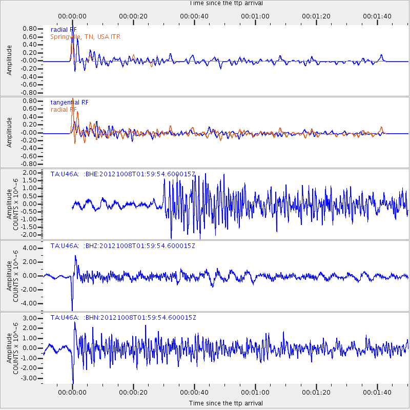
U46A Springville, TN, USA - Earthquake Result Viewer
*The percent match for this event was below the threshold and hence no stack was calculated.
| Earthquake location: |
Chile-Bolivia Border Region |
| Earthquake latitude/longitude: |
-21.7/-68.2 |
| Earthquake time(UTC): |
2012/10/08 (282) 01:50:26 GMT |
| Earthquake Depth: |
122 km |
| Earthquake Magnitude: |
6.0 MB, 5.7 MW, 5.8 MW |
| Earthquake Catalog/Contributor: |
WHDF/NEIC |
|
| Network: |
TA USArray Transportable Network (new EarthScope stations) |
| Station: |
U46A Springville, TN, USA |
| Lat/Lon: |
36.36 N/88.18 W |
| Elevation: |
146 m |
|
| Distance: |
60.8 deg |
| Az: |
341.549 deg |
| Baz: |
158.619 deg |
| Ray Param: |
$rayparam |
*The percent match for this event was below the threshold and hence was not used in the summary stack. |
|
| Radial Match: |
71.42151 % |
| Radial Bump: |
400 |
| Transverse Match: |
48.488117 % |
| Transverse Bump: |
400 |
| SOD ConfigId: |
478790 |
| Insert Time: |
2013-02-23 02:53:44.008 +0000 |
| GWidth: |
2.5 |
| Max Bumps: |
400 |
| Tol: |
0.001 |
|
Signal To Noise
| Channel | StoN | STA | LTA |
| TA:U46A: :BHZ:20121008T01:59:54.600015Z | 7.7055535 | 1.5035445E-6 | 1.9512478E-7 |
| TA:U46A: :BHN:20121008T01:59:54.600015Z | 5.055693 | 1.3859252E-6 | 2.7413157E-7 |
| TA:U46A: :BHE:20121008T01:59:54.600015Z | 5.052963 | 8.6950837E-7 | 1.7207893E-7 |
| Arrivals |
| Ps | |
| PpPs | |
| PsPs/PpSs | |


