You are here: Home > Network List > TA - USArray Transportable Network (new EarthScope stations) Stations List
> Station W47A Westpoint, TN, USA > Earthquake Result Viewer
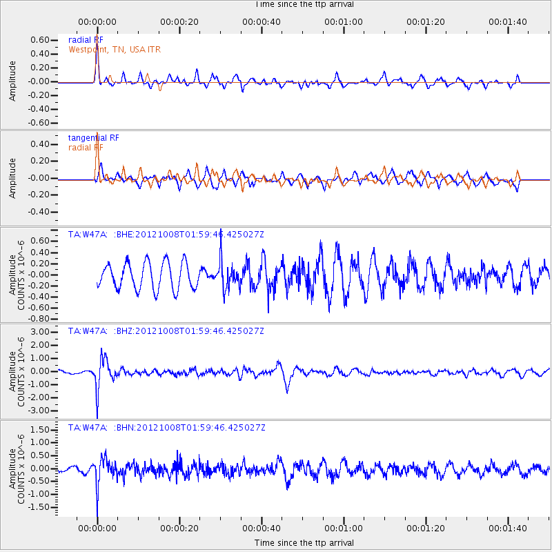
W47A Westpoint, TN, USA - Earthquake Result Viewer
*The percent match for this event was below the threshold and hence no stack was calculated.
| Earthquake location: |
Chile-Bolivia Border Region |
| Earthquake latitude/longitude: |
-21.7/-68.2 |
| Earthquake time(UTC): |
2012/10/08 (282) 01:50:26 GMT |
| Earthquake Depth: |
122 km |
| Earthquake Magnitude: |
6.0 MB, 5.7 MW, 5.8 MW |
| Earthquake Catalog/Contributor: |
WHDF/NEIC |
|
| Network: |
TA USArray Transportable Network (new EarthScope stations) |
| Station: |
W47A Westpoint, TN, USA |
| Lat/Lon: |
35.25 N/87.59 W |
| Elevation: |
293 m |
|
| Distance: |
59.6 deg |
| Az: |
341.597 deg |
| Baz: |
158.982 deg |
| Ray Param: |
$rayparam |
*The percent match for this event was below the threshold and hence was not used in the summary stack. |
|
| Radial Match: |
79.082436 % |
| Radial Bump: |
392 |
| Transverse Match: |
76.917885 % |
| Transverse Bump: |
400 |
| SOD ConfigId: |
478790 |
| Insert Time: |
2013-02-23 02:56:09.361 +0000 |
| GWidth: |
2.5 |
| Max Bumps: |
400 |
| Tol: |
0.001 |
|
Signal To Noise
| Channel | StoN | STA | LTA |
| TA:W47A: :BHZ:20121008T01:59:46.425027Z | 8.323117 | 1.1426225E-6 | 1.3728301E-7 |
| TA:W47A: :BHN:20121008T01:59:46.425027Z | 3.9373028 | 5.0341106E-7 | 1.2785682E-7 |
| TA:W47A: :BHE:20121008T01:59:46.425027Z | 1.0389136 | 2.434019E-7 | 2.3428503E-7 |
| Arrivals |
| Ps | |
| PpPs | |
| PsPs/PpSs | |


