You are here: Home > Network List > TA - USArray Transportable Network (new EarthScope stations) Stations List
> Station 859A Kempfer Cattle CO., St. Cloud, FL, USA > Earthquake Result Viewer
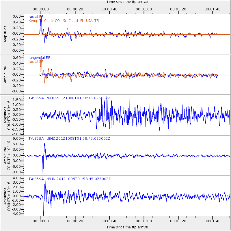
859A Kempfer Cattle CO., St. Cloud, FL, USA - Earthquake Result Viewer
| Earthquake location: |
Chile-Bolivia Border Region |
| Earthquake latitude/longitude: |
-21.7/-68.2 |
| Earthquake time(UTC): |
2012/10/08 (282) 01:50:26 GMT |
| Earthquake Depth: |
122 km |
| Earthquake Magnitude: |
6.0 MB, 5.7 MW, 5.8 MW |
| Earthquake Catalog/Contributor: |
WHDF/NEIC |
|
| Network: |
TA USArray Transportable Network (new EarthScope stations) |
| Station: |
859A Kempfer Cattle CO., St. Cloud, FL, USA |
| Lat/Lon: |
28.06 N/80.90 W |
| Elevation: |
13 m |
|
| Distance: |
51.0 deg |
| Az: |
345.484 deg |
| Baz: |
164.709 deg |
| Ray Param: |
0.067293756 |
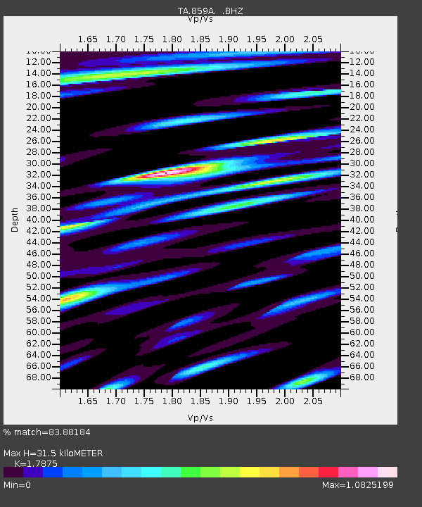
| Estimated Moho Depth: |
31.5 km |
| Estimated Crust Vp/Vs: |
1.79 |
| Assumed Crust Vp: |
6.134 km/s |
| Estimated Crust Vs: |
3.432 km/s |
| Estimated Crust Poisson's Ratio: |
0.27 |
|
| Radial Match: |
83.88184 % |
| Radial Bump: |
400 |
| Transverse Match: |
72.910866 % |
| Transverse Bump: |
400 |
| SOD ConfigId: |
478790 |
| Insert Time: |
2013-02-23 02:57:37.767 +0000 |
| GWidth: |
2.5 |
| Max Bumps: |
400 |
| Tol: |
0.001 |
|
Signal To Noise
| Channel | StoN | STA | LTA |
| TA:859A: :BHZ:20121008T01:58:45.025002Z | 16.424658 | 2.810789E-6 | 1.7113226E-7 |
| TA:859A: :BHN:20121008T01:58:45.025002Z | 6.065509 | 1.5220671E-6 | 2.5093806E-7 |
| TA:859A: :BHE:20121008T01:58:45.025002Z | 1.8602375 | 4.6451396E-7 | 2.4970683E-7 |
| Arrivals |
| Ps | 4.3 SECOND |
| PpPs | 14 SECOND |
| PsPs/PpSs | 18 SECOND |


