You are here: Home > Network List > TA - USArray Transportable Network (new EarthScope stations) Stations List
> Station 957A Wimauma, FL, USA > Earthquake Result Viewer
957A Wimauma, FL, USA - Earthquake Result Viewer
| Earthquake location: |
Chile-Bolivia Border Region |
| Earthquake latitude/longitude: |
-21.7/-68.2 |
| Earthquake time(UTC): |
2012/10/08 (282) 01:50:26 GMT |
| Earthquake Depth: |
122 km |
| Earthquake Magnitude: |
6.0 MB, 5.7 MW, 5.8 MW |
| Earthquake Catalog/Contributor: |
WHDF/NEIC |
|
| Network: |
TA USArray Transportable Network (new EarthScope stations) |
| Station: |
957A Wimauma, FL, USA |
| Lat/Lon: |
27.67 N/82.24 W |
| Elevation: |
35 m |
|
| Distance: |
51.0 deg |
| Az: |
343.881 deg |
| Baz: |
163.078 deg |
| Ray Param: |
0.06732266 |
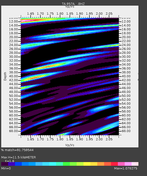
| Estimated Moho Depth: |
11.5 km |
| Estimated Crust Vp/Vs: |
1.60 |
| Assumed Crust Vp: |
5.845 km/s |
| Estimated Crust Vs: |
3.653 km/s |
| Estimated Crust Poisson's Ratio: |
0.18 |
|
| Radial Match: |
91.759544 % |
| Radial Bump: |
400 |
| Transverse Match: |
73.81994 % |
| Transverse Bump: |
400 |
| SOD ConfigId: |
478790 |
| Insert Time: |
2013-02-23 02:57:50.695 +0000 |
| GWidth: |
2.5 |
| Max Bumps: |
400 |
| Tol: |
0.001 |
|

Signal To Noise
| Channel | StoN | STA | LTA |
| TA:957A: :BHZ:20121008T01:58:44.69999Z | 12.958033 | 4.095219E-6 | 3.1603713E-7 |
| TA:957A: :BHN:20121008T01:58:44.69999Z | 5.215503 | 2.1093579E-6 | 4.0443993E-7 |
| TA:957A: :BHE:20121008T01:58:44.69999Z | 1.6035265 | 8.1090974E-7 | 5.05704E-7 |
| Arrivals |
| Ps | 1.2 SECOND |
| PpPs | 4.9 SECOND |
| PsPs/PpSs | 6.1 SECOND |


