You are here: Home > Network List > TA - USArray Transportable Network (new EarthScope stations) Stations List
> Station 256A Glennville, GA, USA > Earthquake Result Viewer
256A Glennville, GA, USA - Earthquake Result Viewer
| Earthquake location: |
Chile-Bolivia Border Region |
| Earthquake latitude/longitude: |
-21.7/-68.2 |
| Earthquake time(UTC): |
2012/10/08 (282) 01:50:26 GMT |
| Earthquake Depth: |
122 km |
| Earthquake Magnitude: |
6.0 MB, 5.7 MW, 5.8 MW |
| Earthquake Catalog/Contributor: |
WHDF/NEIC |
|
| Network: |
TA USArray Transportable Network (new EarthScope stations) |
| Station: |
256A Glennville, GA, USA |
| Lat/Lon: |
31.98 N/81.89 W |
| Elevation: |
46 m |
|
| Distance: |
55.0 deg |
| Az: |
345.752 deg |
| Baz: |
164.378 deg |
| Ray Param: |
0.06469762 |
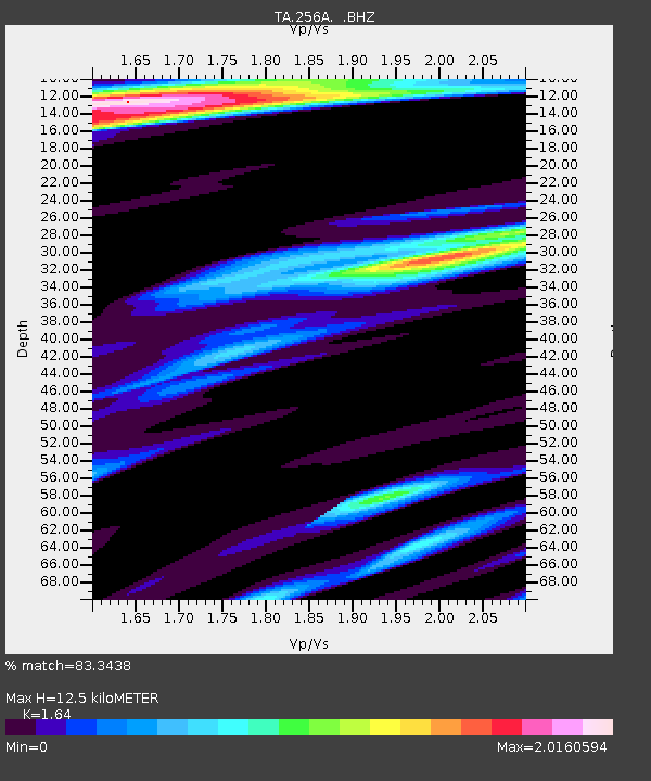
| Estimated Moho Depth: |
12.5 km |
| Estimated Crust Vp/Vs: |
1.64 |
| Assumed Crust Vp: |
5.989 km/s |
| Estimated Crust Vs: |
3.652 km/s |
| Estimated Crust Poisson's Ratio: |
0.20 |
|
| Radial Match: |
83.3438 % |
| Radial Bump: |
400 |
| Transverse Match: |
60.165653 % |
| Transverse Bump: |
400 |
| SOD ConfigId: |
478790 |
| Insert Time: |
2013-02-23 02:59:08.541 +0000 |
| GWidth: |
2.5 |
| Max Bumps: |
400 |
| Tol: |
0.001 |
|

Signal To Noise
| Channel | StoN | STA | LTA |
| TA:256A: :BHZ:20121008T01:59:14.249978Z | 16.28546 | 2.6298958E-6 | 1.6148736E-7 |
| TA:256A: :BHN:20121008T01:59:14.249978Z | 4.897068 | 1.2097195E-6 | 2.4702936E-7 |
| TA:256A: :BHE:20121008T01:59:14.249978Z | 1.4719653 | 3.5427053E-7 | 2.406786E-7 |
| Arrivals |
| Ps | 1.4 SECOND |
| PpPs | 5.3 SECOND |
| PsPs/PpSs | 6.7 SECOND |


