You are here: Home > Network List > TA - USArray Transportable Network (new EarthScope stations) Stations List
> Station Y53A Monroe, GA, USA > Earthquake Result Viewer
Y53A Monroe, GA, USA - Earthquake Result Viewer
| Earthquake location: |
Chile-Bolivia Border Region |
| Earthquake latitude/longitude: |
-21.7/-68.2 |
| Earthquake time(UTC): |
2012/10/08 (282) 01:50:26 GMT |
| Earthquake Depth: |
122 km |
| Earthquake Magnitude: |
6.0 MB, 5.7 MW, 5.8 MW |
| Earthquake Catalog/Contributor: |
WHDF/NEIC |
|
| Network: |
TA USArray Transportable Network (new EarthScope stations) |
| Station: |
Y53A Monroe, GA, USA |
| Lat/Lon: |
33.86 N/83.58 W |
| Elevation: |
234 m |
|
| Distance: |
57.2 deg |
| Az: |
344.737 deg |
| Baz: |
162.894 deg |
| Ray Param: |
0.063283175 |
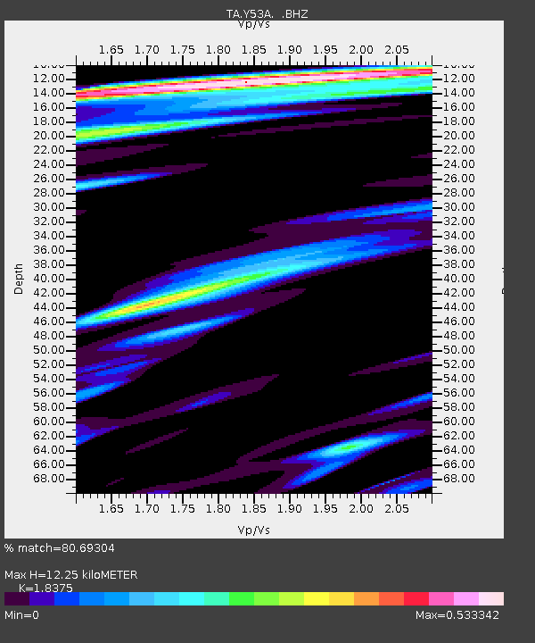
| Estimated Moho Depth: |
12.25 km |
| Estimated Crust Vp/Vs: |
1.84 |
| Assumed Crust Vp: |
6.565 km/s |
| Estimated Crust Vs: |
3.573 km/s |
| Estimated Crust Poisson's Ratio: |
0.29 |
|
| Radial Match: |
80.69304 % |
| Radial Bump: |
400 |
| Transverse Match: |
73.142715 % |
| Transverse Bump: |
400 |
| SOD ConfigId: |
478790 |
| Insert Time: |
2013-02-23 03:00:39.022 +0000 |
| GWidth: |
2.5 |
| Max Bumps: |
400 |
| Tol: |
0.001 |
|

Signal To Noise
| Channel | StoN | STA | LTA |
| TA:Y53A: :BHZ:20121008T01:59:29.82499Z | 3.4246616 | 8.738201E-7 | 2.5515516E-7 |
| TA:Y53A: :BHN:20121008T01:59:29.82499Z | 3.1745245 | 4.0643272E-7 | 1.2802948E-7 |
| TA:Y53A: :BHE:20121008T01:59:29.82499Z | 1.5281023 | 1.6093756E-7 | 1.05318584E-7 |
| Arrivals |
| Ps | 1.6 SECOND |
| PpPs | 5.0 SECOND |
| PsPs/PpSs | 6.7 SECOND |


