You are here: Home > Network List > UW - Pacific Northwest Regional Seismic Network Stations List
> Station MRBL Marblemount, WA, USA > Earthquake Result Viewer
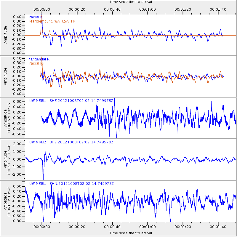
MRBL Marblemount, WA, USA - Earthquake Result Viewer
*The percent match for this event was below the threshold and hence no stack was calculated.
| Earthquake location: |
Chile-Bolivia Border Region |
| Earthquake latitude/longitude: |
-21.7/-68.2 |
| Earthquake time(UTC): |
2012/10/08 (282) 01:50:26 GMT |
| Earthquake Depth: |
122 km |
| Earthquake Magnitude: |
6.0 MB, 5.7 MW, 5.8 MW |
| Earthquake Catalog/Contributor: |
WHDF/NEIC |
|
| Network: |
UW Pacific Northwest Regional Seismic Network |
| Station: |
MRBL Marblemount, WA, USA |
| Lat/Lon: |
48.52 N/121.48 W |
| Elevation: |
75 m |
|
| Distance: |
84.6 deg |
| Az: |
327.615 deg |
| Baz: |
131.492 deg |
| Ray Param: |
$rayparam |
*The percent match for this event was below the threshold and hence was not used in the summary stack. |
|
| Radial Match: |
76.625206 % |
| Radial Bump: |
400 |
| Transverse Match: |
75.362144 % |
| Transverse Bump: |
400 |
| SOD ConfigId: |
478790 |
| Insert Time: |
2013-02-23 03:07:16.713 +0000 |
| GWidth: |
2.5 |
| Max Bumps: |
400 |
| Tol: |
0.001 |
|
Signal To Noise
| Channel | StoN | STA | LTA |
| UW:MRBL: :BHZ:20121008T02:02:14.749978Z | 3.4344745 | 8.236721E-7 | 2.398248E-7 |
| UW:MRBL: :BHN:20121008T02:02:14.749978Z | 1.2804713 | 2.8036487E-7 | 2.1895444E-7 |
| UW:MRBL: :BHE:20121008T02:02:14.749978Z | 1.2226149 | 2.0744876E-7 | 1.696763E-7 |
| Arrivals |
| Ps | |
| PpPs | |
| PsPs/PpSs | |


