You are here: Home > Network List > UW - Pacific Northwest Regional Seismic Network Stations List
> Station UMAT Pilot Rock, OR, USA > Earthquake Result Viewer
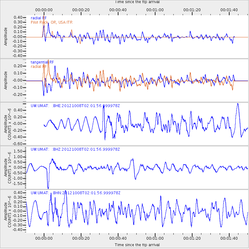
UMAT Pilot Rock, OR, USA - Earthquake Result Viewer
*The percent match for this event was below the threshold and hence no stack was calculated.
| Earthquake location: |
Chile-Bolivia Border Region |
| Earthquake latitude/longitude: |
-21.7/-68.2 |
| Earthquake time(UTC): |
2012/10/08 (282) 01:50:26 GMT |
| Earthquake Depth: |
122 km |
| Earthquake Magnitude: |
6.0 MB, 5.7 MW, 5.8 MW |
| Earthquake Catalog/Contributor: |
WHDF/NEIC |
|
| Network: |
UW Pacific Northwest Regional Seismic Network |
| Station: |
UMAT Pilot Rock, OR, USA |
| Lat/Lon: |
45.29 N/118.96 W |
| Elevation: |
1318 m |
|
| Distance: |
81.1 deg |
| Az: |
326.385 deg |
| Baz: |
133.178 deg |
| Ray Param: |
$rayparam |
*The percent match for this event was below the threshold and hence was not used in the summary stack. |
|
| Radial Match: |
68.28086 % |
| Radial Bump: |
400 |
| Transverse Match: |
64.699486 % |
| Transverse Bump: |
400 |
| SOD ConfigId: |
478790 |
| Insert Time: |
2013-02-23 03:07:28.891 +0000 |
| GWidth: |
2.5 |
| Max Bumps: |
400 |
| Tol: |
0.001 |
|
Signal To Noise
| Channel | StoN | STA | LTA |
| UW:UMAT: :BHZ:20121008T02:01:56.999978Z | 3.0174189 | 7.722026E-7 | 2.5591496E-7 |
| UW:UMAT: :BHN:20121008T02:01:56.999978Z | 1.0910087 | 1.6337562E-7 | 1.4974731E-7 |
| UW:UMAT: :BHE:20121008T02:01:56.999978Z | 2.3301098 | 2.573954E-7 | 1.1046492E-7 |
| Arrivals |
| Ps | |
| PpPs | |
| PsPs/PpSs | |


