You are here: Home > Network List > UW - Pacific Northwest Regional Seismic Network Stations List
> Station LEBA Lebam, WA, USA > Earthquake Result Viewer
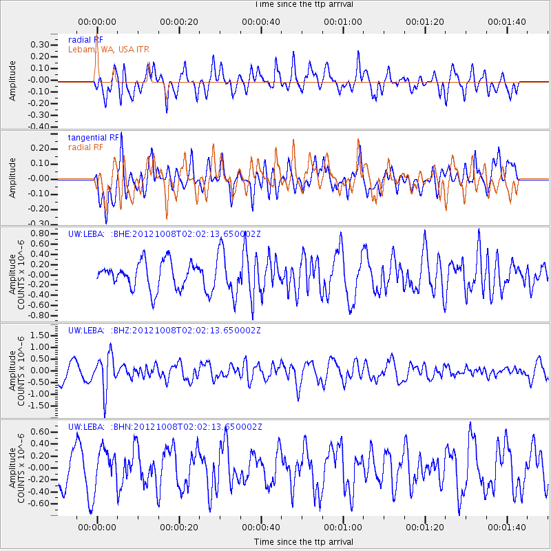
LEBA Lebam, WA, USA - Earthquake Result Viewer
*The percent match for this event was below the threshold and hence no stack was calculated.
| Earthquake location: |
Chile-Bolivia Border Region |
| Earthquake latitude/longitude: |
-21.7/-68.2 |
| Earthquake time(UTC): |
2012/10/08 (282) 01:50:26 GMT |
| Earthquake Depth: |
122 km |
| Earthquake Magnitude: |
6.0 MB, 5.7 MW, 5.8 MW |
| Earthquake Catalog/Contributor: |
WHDF/NEIC |
|
| Network: |
UW Pacific Northwest Regional Seismic Network |
| Station: |
LEBA Lebam, WA, USA |
| Lat/Lon: |
46.55 N/123.56 W |
| Elevation: |
73 m |
|
| Distance: |
84.4 deg |
| Az: |
325.189 deg |
| Baz: |
129.73 deg |
| Ray Param: |
$rayparam |
*The percent match for this event was below the threshold and hence was not used in the summary stack. |
|
| Radial Match: |
59.04246 % |
| Radial Bump: |
400 |
| Transverse Match: |
59.842598 % |
| Transverse Bump: |
400 |
| SOD ConfigId: |
478790 |
| Insert Time: |
2013-02-23 03:07:29.007 +0000 |
| GWidth: |
2.5 |
| Max Bumps: |
400 |
| Tol: |
0.001 |
|
Signal To Noise
| Channel | StoN | STA | LTA |
| UW:LEBA: :BHZ:20121008T02:02:13.650002Z | 2.1269906 | 7.6739593E-7 | 3.6078953E-7 |
| UW:LEBA: :BHN:20121008T02:02:13.650002Z | 0.8421009 | 2.9872544E-7 | 3.547383E-7 |
| UW:LEBA: :BHE:20121008T02:02:13.650002Z | 1.6987152 | 4.2915997E-7 | 2.5263796E-7 |
| Arrivals |
| Ps | |
| PpPs | |
| PsPs/PpSs | |


