You are here: Home > Network List > G - GEOSCOPE Stations List
> Station WUS Wushi, Xinjiang Uygur, China > Earthquake Result Viewer
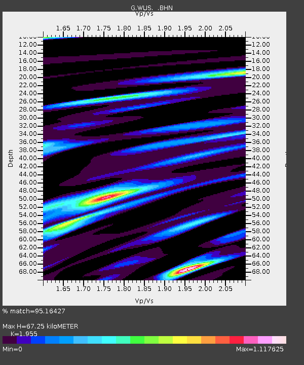
WUS Wushi, Xinjiang Uygur, China - Earthquake Result Viewer
| Earthquake location: |
Minahassa Peninsula, Sulawesi |
| Earthquake latitude/longitude: |
1.0/120.4 |
| Earthquake time(UTC): |
1996/07/22 (204) 14:19:35 GMT |
| Earthquake Depth: |
33 km |
| Earthquake Magnitude: |
6.0 MB, 6.9 MS, 7.0 UNKNOWN, 6.9 MW |
| Earthquake Catalog/Contributor: |
WHDF/NEIC |
|
| Network: |
G GEOSCOPE |
| Station: |
WUS Wushi, Xinjiang Uygur, China |
| Lat/Lon: |
41.20 N/79.22 E |
| Elevation: |
1457 m |
|
| Distance: |
54.6 deg |
| Az: |
322.416 deg |
| Baz: |
126.086 deg |
| Ray Param: |
0.06526692 |
| Estimated Moho Depth: |
67.25 km |
| Estimated Crust Vp/Vs: |
1.96 |
| Assumed Crust Vp: |
6.353 km/s |
| Estimated Crust Vs: |
3.25 km/s |
| Estimated Crust Poisson's Ratio: |
0.32 |
|
| Radial Match: |
95.16427 % |
| Radial Bump: |
400 |
| Transverse Match: |
85.72945 % |
| Transverse Bump: |
400 |
| SOD ConfigId: |
6273 |
| Insert Time: |
2010-02-27 00:57:02.452 +0000 |
| GWidth: |
2.5 |
| Max Bumps: |
400 |
| Tol: |
0.001 |
|

Signal To Noise
| Channel | StoN | STA | LTA |
| G:WUS: :BHN:19960722T14:28:30.499011Z | 2.9212828 | 2.8237218E-7 | 9.6660344E-8 |
| G:WUS: :BHE:19960722T14:28:30.499011Z | 5.838126 | 3.3922007E-7 | 5.8104273E-8 |
| G:WUS: :BHZ:19960722T14:28:30.499011Z | 14.690638 | 9.4084334E-7 | 6.404374E-8 |
| Arrivals |
| Ps | 11 SECOND |
| PpPs | 30 SECOND |
| PsPs/PpSs | 40 SECOND |


