You are here: Home > Network List > CN - Canadian National Seismograph Network Stations List
> Station INK INUVIK, NT > Earthquake Result Viewer
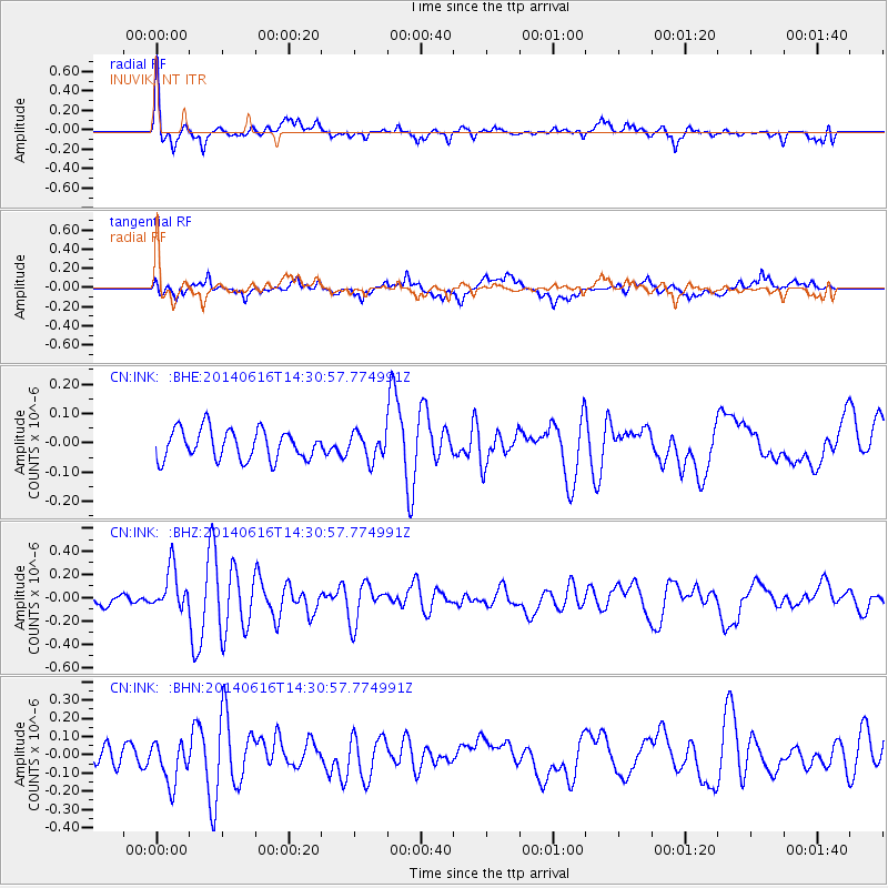
INK INUVIK, NT - Earthquake Result Viewer
*The percent match for this event was below the threshold and hence no stack was calculated.
| Earthquake location: |
Jan Mayen Island Region |
| Earthquake latitude/longitude: |
70.4/-15.2 |
| Earthquake time(UTC): |
2014/06/16 (167) 14:24:31 GMT |
| Earthquake Depth: |
11 km |
| Earthquake Magnitude: |
5.5 MW |
| Earthquake Catalog/Contributor: |
ISC/ISC |
|
| Network: |
CN Canadian National Seismograph Network |
| Station: |
INK INUVIK, NT |
| Lat/Lon: |
68.31 N/133.53 W |
| Elevation: |
44 m |
|
| Distance: |
35.5 deg |
| Az: |
325.703 deg |
| Baz: |
30.804 deg |
| Ray Param: |
$rayparam |
*The percent match for this event was below the threshold and hence was not used in the summary stack. |
|
| Radial Match: |
78.09497 % |
| Radial Bump: |
384 |
| Transverse Match: |
64.11572 % |
| Transverse Bump: |
400 |
| SOD ConfigId: |
3390531 |
| Insert Time: |
2019-04-12 07:48:44.952 +0000 |
| GWidth: |
2.5 |
| Max Bumps: |
400 |
| Tol: |
0.001 |
|
Signal To Noise
| Channel | StoN | STA | LTA |
| CN:INK: :BHZ:20140616T14:30:57.774991Z | 4.1624737 | 1.8153389E-7 | 4.3612026E-8 |
| CN:INK: :BHN:20140616T14:30:57.774991Z | 3.5619524 | 1.1870948E-7 | 3.332708E-8 |
| CN:INK: :BHE:20140616T14:30:57.774991Z | 0.8706696 | 4.428439E-8 | 5.0862454E-8 |
| Arrivals |
| Ps | |
| PpPs | |
| PsPs/PpSs | |


