You are here: Home > Network List > UW - Pacific Northwest Regional Seismic Network Stations List
> Station PASS Maple Falls, WA, USA > Earthquake Result Viewer
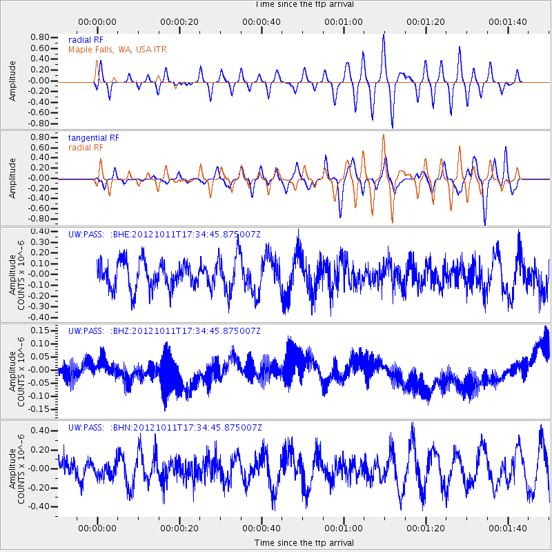
PASS Maple Falls, WA, USA - Earthquake Result Viewer
*The percent match for this event was below the threshold and hence no stack was calculated.
| Earthquake location: |
Chile-Argentina Border Region |
| Earthquake latitude/longitude: |
-32.9/-70.3 |
| Earthquake time(UTC): |
2012/10/11 (285) 17:22:09 GMT |
| Earthquake Depth: |
82 km |
| Earthquake Magnitude: |
5.5 MB, 5.5 MW, 5.6 MW |
| Earthquake Catalog/Contributor: |
WHDF/NEIC |
|
| Network: |
UW Pacific Northwest Regional Seismic Network |
| Station: |
PASS Maple Falls, WA, USA |
| Lat/Lon: |
49.00 N/122.09 W |
| Elevation: |
174 m |
|
| Distance: |
93.6 deg |
| Az: |
328.773 deg |
| Baz: |
138.51 deg |
| Ray Param: |
$rayparam |
*The percent match for this event was below the threshold and hence was not used in the summary stack. |
|
| Radial Match: |
31.576574 % |
| Radial Bump: |
400 |
| Transverse Match: |
31.621216 % |
| Transverse Bump: |
400 |
| SOD ConfigId: |
478790 |
| Insert Time: |
2013-02-23 03:26:54.924 +0000 |
| GWidth: |
2.5 |
| Max Bumps: |
400 |
| Tol: |
0.001 |
|
Signal To Noise
| Channel | StoN | STA | LTA |
| UW:PASS: :BHZ:20121011T17:34:45.875007Z | 0.63550526 | 3.782755E-8 | 5.9523583E-8 |
| UW:PASS: :BHN:20121011T17:34:45.875007Z | 0.57898134 | 7.6086216E-8 | 1.3141393E-7 |
| UW:PASS: :BHE:20121011T17:34:45.875007Z | 1.468758 | 1.7741806E-7 | 1.2079461E-7 |
| Arrivals |
| Ps | |
| PpPs | |
| PsPs/PpSs | |


