You are here: Home > Network List > AZ - ANZA Regional Network Stations List
> Station SMER AZ.SMER > Earthquake Result Viewer
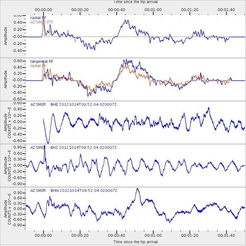
SMER AZ.SMER - Earthquake Result Viewer
*The percent match for this event was below the threshold and hence no stack was calculated.
| Earthquake location: |
Kuril Islands |
| Earthquake latitude/longitude: |
48.3/154.4 |
| Earthquake time(UTC): |
2012/10/14 (288) 09:41:58 GMT |
| Earthquake Depth: |
35 km |
| Earthquake Magnitude: |
5.7 MB, 5.2 MS, 5.7 MW, 5.7 MW |
| Earthquake Catalog/Contributor: |
WHDF/NEIC |
|
| Network: |
AZ ANZA Regional Network |
| Station: |
SMER AZ.SMER |
| Lat/Lon: |
33.46 N/117.17 W |
| Elevation: |
355 m |
|
| Distance: |
64.9 deg |
| Az: |
67.334 deg |
| Baz: |
312.531 deg |
| Ray Param: |
$rayparam |
*The percent match for this event was below the threshold and hence was not used in the summary stack. |
|
| Radial Match: |
70.362785 % |
| Radial Bump: |
400 |
| Transverse Match: |
74.44745 % |
| Transverse Bump: |
400 |
| SOD ConfigId: |
478790 |
| Insert Time: |
2013-02-23 03:38:43.900 +0000 |
| GWidth: |
2.5 |
| Max Bumps: |
400 |
| Tol: |
0.001 |
|
Signal To Noise
| Channel | StoN | STA | LTA |
| AZ:SMER: :BHZ:20121014T09:52:04.020007Z | 2.525257 | 3.6130874E-7 | 1.4307798E-7 |
| AZ:SMER: :BHN:20121014T09:52:04.020007Z | 2.4373307 | 4.250008E-7 | 1.743714E-7 |
| AZ:SMER: :BHE:20121014T09:52:04.020007Z | 0.7058898 | 1.5825869E-7 | 2.2419744E-7 |
| Arrivals |
| Ps | |
| PpPs | |
| PsPs/PpSs | |


