You are here: Home > Network List > BK - Berkeley Digital Seismograph Network Stations List
> Station HUMO Hull Mountain, OR > Earthquake Result Viewer
HUMO Hull Mountain, OR - Earthquake Result Viewer
*The percent match for this event was below the threshold and hence no stack was calculated.
| Earthquake location: |
Kuril Islands |
| Earthquake latitude/longitude: |
48.3/154.4 |
| Earthquake time(UTC): |
2012/10/14 (288) 09:41:58 GMT |
| Earthquake Depth: |
35 km |
| Earthquake Magnitude: |
5.7 MB, 5.2 MS, 5.7 MW, 5.7 MW |
| Earthquake Catalog/Contributor: |
WHDF/NEIC |
|
| Network: |
BK Berkeley Digital Seismograph Network |
| Station: |
HUMO Hull Mountain, OR |
| Lat/Lon: |
42.61 N/122.96 W |
| Elevation: |
555 m |
|
| Distance: |
55.6 deg |
| Az: |
62.591 deg |
| Baz: |
306.604 deg |
| Ray Param: |
$rayparam |
*The percent match for this event was below the threshold and hence was not used in the summary stack. |
|
| Radial Match: |
64.38465 % |
| Radial Bump: |
400 |
| Transverse Match: |
58.07956 % |
| Transverse Bump: |
400 |
| SOD ConfigId: |
478790 |
| Insert Time: |
2013-02-23 03:38:58.899 +0000 |
| GWidth: |
2.5 |
| Max Bumps: |
400 |
| Tol: |
0.001 |
|
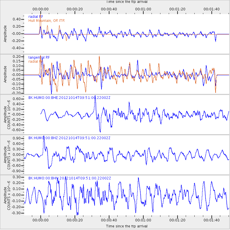
Signal To Noise
| Channel | StoN | STA | LTA |
| BK:HUMO:00:BHZ:20121014T09:51:00.22002Z | 2.4122176 | 4.306572E-7 | 1.7853164E-7 |
| BK:HUMO:00:BHN:20121014T09:51:00.22002Z | 1.3726251 | 1.2643271E-7 | 9.2110156E-8 |
| BK:HUMO:00:BHE:20121014T09:51:00.22002Z | 3.218079 | 3.1071232E-7 | 9.6552114E-8 |
| Arrivals |
| Ps | |
| PpPs | |
| PsPs/PpSs | |


