You are here: Home > Network List > CI - Caltech Regional Seismic Network Stations List
> Station GSC Goldstone, Goldstone Lake, CA, USA > Earthquake Result Viewer
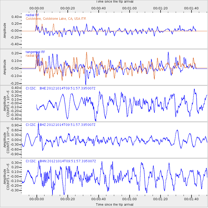
GSC Goldstone, Goldstone Lake, CA, USA - Earthquake Result Viewer
*The percent match for this event was below the threshold and hence no stack was calculated.
| Earthquake location: |
Kuril Islands |
| Earthquake latitude/longitude: |
48.3/154.4 |
| Earthquake time(UTC): |
2012/10/14 (288) 09:41:58 GMT |
| Earthquake Depth: |
35 km |
| Earthquake Magnitude: |
5.7 MB, 5.2 MS, 5.7 MW, 5.7 MW |
| Earthquake Catalog/Contributor: |
WHDF/NEIC |
|
| Network: |
CI Caltech Regional Seismic Network |
| Station: |
GSC Goldstone, Goldstone Lake, CA, USA |
| Lat/Lon: |
35.30 N/116.81 W |
| Elevation: |
1000 m |
|
| Distance: |
63.9 deg |
| Az: |
65.599 deg |
| Baz: |
311.986 deg |
| Ray Param: |
$rayparam |
*The percent match for this event was below the threshold and hence was not used in the summary stack. |
|
| Radial Match: |
52.987816 % |
| Radial Bump: |
400 |
| Transverse Match: |
51.865635 % |
| Transverse Bump: |
400 |
| SOD ConfigId: |
478790 |
| Insert Time: |
2013-02-23 03:39:50.965 +0000 |
| GWidth: |
2.5 |
| Max Bumps: |
400 |
| Tol: |
0.001 |
|
Signal To Noise
| Channel | StoN | STA | LTA |
| CI:GSC: :BHZ:20121014T09:51:57.395007Z | 2.3337038 | 4.202691E-7 | 1.8008674E-7 |
| CI:GSC: :BHN:20121014T09:51:57.395007Z | 1.5952814 | 1.5182437E-7 | 9.5170904E-8 |
| CI:GSC: :BHE:20121014T09:51:57.395007Z | 0.86085016 | 1.2677613E-7 | 1.4726852E-7 |
| Arrivals |
| Ps | |
| PpPs | |
| PsPs/PpSs | |


