You are here: Home > Network List > CI - Caltech Regional Seismic Network Stations List
> Station VCS Vincent Substation, Palmdale, CA, USA > Earthquake Result Viewer
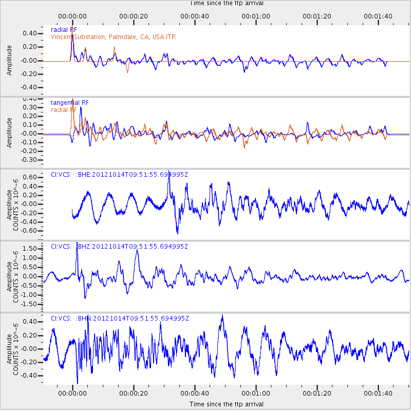
VCS Vincent Substation, Palmdale, CA, USA - Earthquake Result Viewer
*The percent match for this event was below the threshold and hence no stack was calculated.
| Earthquake location: |
Kuril Islands |
| Earthquake latitude/longitude: |
48.3/154.4 |
| Earthquake time(UTC): |
2012/10/14 (288) 09:41:58 GMT |
| Earthquake Depth: |
35 km |
| Earthquake Magnitude: |
5.7 MB, 5.2 MS, 5.7 MW, 5.7 MW |
| Earthquake Catalog/Contributor: |
WHDF/NEIC |
|
| Network: |
CI Caltech Regional Seismic Network |
| Station: |
VCS Vincent Substation, Palmdale, CA, USA |
| Lat/Lon: |
34.48 N/118.12 W |
| Elevation: |
991 m |
|
| Distance: |
63.6 deg |
| Az: |
67.08 deg |
| Baz: |
311.894 deg |
| Ray Param: |
$rayparam |
*The percent match for this event was below the threshold and hence was not used in the summary stack. |
|
| Radial Match: |
67.76284 % |
| Radial Bump: |
400 |
| Transverse Match: |
57.481647 % |
| Transverse Bump: |
400 |
| SOD ConfigId: |
478790 |
| Insert Time: |
2013-02-23 03:41:11.473 +0000 |
| GWidth: |
2.5 |
| Max Bumps: |
400 |
| Tol: |
0.001 |
|
Signal To Noise
| Channel | StoN | STA | LTA |
| CI:VCS: :BHZ:20121014T09:51:55.694995Z | 4.384047 | 6.33417E-7 | 1.4448226E-7 |
| CI:VCS: :BHN:20121014T09:51:55.694995Z | 1.3598855 | 1.8327364E-7 | 1.3477138E-7 |
| CI:VCS: :BHE:20121014T09:51:55.694995Z | 1.7377874 | 3.2632946E-7 | 1.8778447E-7 |
| Arrivals |
| Ps | |
| PpPs | |
| PsPs/PpSs | |


