You are here: Home > Network List > CI - Caltech Regional Seismic Network Stations List
> Station MPP McPhearson Peak > Earthquake Result Viewer
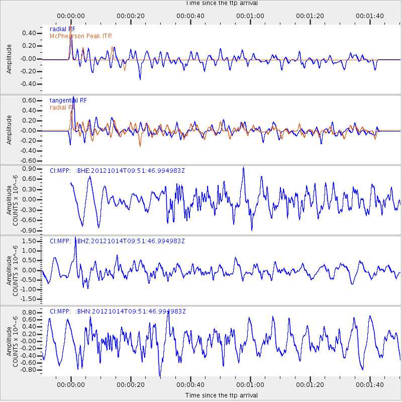
MPP McPhearson Peak - Earthquake Result Viewer
*The percent match for this event was below the threshold and hence no stack was calculated.
| Earthquake location: |
Kuril Islands |
| Earthquake latitude/longitude: |
48.3/154.4 |
| Earthquake time(UTC): |
2012/10/14 (288) 09:41:58 GMT |
| Earthquake Depth: |
35 km |
| Earthquake Magnitude: |
5.7 MB, 5.2 MS, 5.7 MW, 5.7 MW |
| Earthquake Catalog/Contributor: |
WHDF/NEIC |
|
| Network: |
CI Caltech Regional Seismic Network |
| Station: |
MPP McPhearson Peak |
| Lat/Lon: |
34.89 N/119.81 W |
| Elevation: |
1739 m |
|
| Distance: |
62.3 deg |
| Az: |
67.781 deg |
| Baz: |
311.252 deg |
| Ray Param: |
$rayparam |
*The percent match for this event was below the threshold and hence was not used in the summary stack. |
|
| Radial Match: |
66.88251 % |
| Radial Bump: |
400 |
| Transverse Match: |
70.06202 % |
| Transverse Bump: |
400 |
| SOD ConfigId: |
478790 |
| Insert Time: |
2013-02-23 03:42:28.511 +0000 |
| GWidth: |
2.5 |
| Max Bumps: |
400 |
| Tol: |
0.001 |
|
Signal To Noise
| Channel | StoN | STA | LTA |
| CI:MPP: :BHZ:20121014T09:51:46.994983Z | 2.2210867 | 6.059236E-7 | 2.72805E-7 |
| CI:MPP: :BHN:20121014T09:51:46.994983Z | 1.3795652 | 4.1615291E-7 | 3.0165512E-7 |
| CI:MPP: :BHE:20121014T09:51:46.994983Z | 1.0066513 | 3.1631416E-7 | 3.142242E-7 |
| Arrivals |
| Ps | |
| PpPs | |
| PsPs/PpSs | |


