You are here: Home > Network List > G - GEOSCOPE Stations List
> Station WUS Wushi, Xinjiang Uygur, China > Earthquake Result Viewer
WUS Wushi, Xinjiang Uygur, China - Earthquake Result Viewer
| Earthquake location: |
Mariana Islands |
| Earthquake latitude/longitude: |
14.0/144.9 |
| Earthquake time(UTC): |
1997/04/23 (113) 19:44:28 GMT |
| Earthquake Depth: |
101 km |
| Earthquake Magnitude: |
6.2 MB, 6.5 UNKNOWN, 6.5 MW |
| Earthquake Catalog/Contributor: |
WHDF/NEIC |
|
| Network: |
G GEOSCOPE |
| Station: |
WUS Wushi, Xinjiang Uygur, China |
| Lat/Lon: |
41.20 N/79.22 E |
| Elevation: |
1457 m |
|
| Distance: |
62.7 deg |
| Az: |
309.275 deg |
| Baz: |
95.236 deg |
| Ray Param: |
0.05980408 |
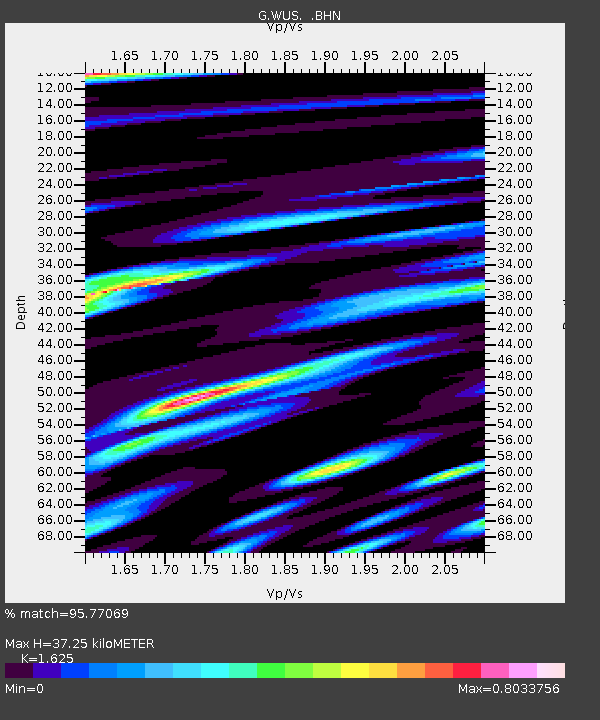
| Estimated Moho Depth: |
37.25 km |
| Estimated Crust Vp/Vs: |
1.62 |
| Assumed Crust Vp: |
6.353 km/s |
| Estimated Crust Vs: |
3.91 km/s |
| Estimated Crust Poisson's Ratio: |
0.20 |
|
| Radial Match: |
95.77069 % |
| Radial Bump: |
400 |
| Transverse Match: |
84.17657 % |
| Transverse Bump: |
400 |
| SOD ConfigId: |
6273 |
| Insert Time: |
2010-02-27 00:57:35.684 +0000 |
| GWidth: |
2.5 |
| Max Bumps: |
400 |
| Tol: |
0.001 |
|

Signal To Noise
| Channel | StoN | STA | LTA |
| G:WUS: :BHN:19970423T19:54:11.600012Z | 0.77023596 | 3.962997E-8 | 5.1451728E-8 |
| G:WUS: :BHE:19970423T19:54:11.600012Z | 1.5901963 | 1.0764301E-7 | 6.769165E-8 |
| G:WUS: :BHZ:19970423T19:54:11.600012Z | 4.25437 | 3.0444474E-7 | 7.1560464E-8 |
| Arrivals |
| Ps | 3.8 SECOND |
| PpPs | 15 SECOND |
| PsPs/PpSs | 19 SECOND |


