You are here: Home > Network List > TA - USArray Transportable Network (new EarthScope stations) Stations List
> Station M04C Macdoel, CA, USA > Earthquake Result Viewer
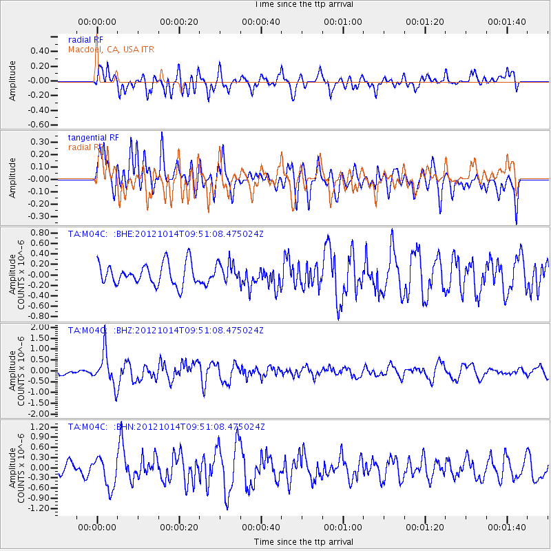
M04C Macdoel, CA, USA - Earthquake Result Viewer
*The percent match for this event was below the threshold and hence no stack was calculated.
| Earthquake location: |
Kuril Islands |
| Earthquake latitude/longitude: |
48.3/154.4 |
| Earthquake time(UTC): |
2012/10/14 (288) 09:41:58 GMT |
| Earthquake Depth: |
35 km |
| Earthquake Magnitude: |
5.7 MB, 5.2 MS, 5.7 MW, 5.7 MW |
| Earthquake Catalog/Contributor: |
WHDF/NEIC |
|
| Network: |
TA USArray Transportable Network (new EarthScope stations) |
| Station: |
M04C Macdoel, CA, USA |
| Lat/Lon: |
41.78 N/121.84 W |
| Elevation: |
1391 m |
|
| Distance: |
56.7 deg |
| Az: |
62.781 deg |
| Baz: |
307.457 deg |
| Ray Param: |
$rayparam |
*The percent match for this event was below the threshold and hence was not used in the summary stack. |
|
| Radial Match: |
68.95003 % |
| Radial Bump: |
400 |
| Transverse Match: |
55.004745 % |
| Transverse Bump: |
400 |
| SOD ConfigId: |
478790 |
| Insert Time: |
2013-02-23 03:49:00.449 +0000 |
| GWidth: |
2.5 |
| Max Bumps: |
400 |
| Tol: |
0.001 |
|
Signal To Noise
| Channel | StoN | STA | LTA |
| TA:M04C: :BHZ:20121014T09:51:08.475024Z | 6.0810075 | 7.8574374E-7 | 1.2921275E-7 |
| TA:M04C: :BHN:20121014T09:51:08.475024Z | 1.4815738 | 4.5933274E-7 | 3.100303E-7 |
| TA:M04C: :BHE:20121014T09:51:08.475024Z | 0.92097646 | 1.8837981E-7 | 2.0454357E-7 |
| Arrivals |
| Ps | |
| PpPs | |
| PsPs/PpSs | |


