You are here: Home > Network List > TA - USArray Transportable Network (new EarthScope stations) Stations List
> Station L04D Klamath Falls, OR, USA > Earthquake Result Viewer
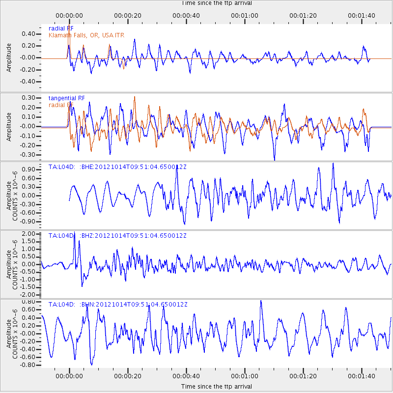
L04D Klamath Falls, OR, USA - Earthquake Result Viewer
*The percent match for this event was below the threshold and hence no stack was calculated.
| Earthquake location: |
Kuril Islands |
| Earthquake latitude/longitude: |
48.3/154.4 |
| Earthquake time(UTC): |
2012/10/14 (288) 09:41:58 GMT |
| Earthquake Depth: |
35 km |
| Earthquake Magnitude: |
5.7 MB, 5.2 MS, 5.7 MW, 5.7 MW |
| Earthquake Catalog/Contributor: |
WHDF/NEIC |
|
| Network: |
TA USArray Transportable Network (new EarthScope stations) |
| Station: |
L04D Klamath Falls, OR, USA |
| Lat/Lon: |
42.22 N/122.30 W |
| Elevation: |
1437 m |
|
| Distance: |
56.2 deg |
| Az: |
62.617 deg |
| Baz: |
307.057 deg |
| Ray Param: |
$rayparam |
*The percent match for this event was below the threshold and hence was not used in the summary stack. |
|
| Radial Match: |
58.46825 % |
| Radial Bump: |
400 |
| Transverse Match: |
56.635548 % |
| Transverse Bump: |
391 |
| SOD ConfigId: |
478790 |
| Insert Time: |
2013-02-23 03:51:21.138 +0000 |
| GWidth: |
2.5 |
| Max Bumps: |
400 |
| Tol: |
0.001 |
|
Signal To Noise
| Channel | StoN | STA | LTA |
| TA:L04D: :BHZ:20121014T09:51:04.650012Z | 4.660374 | 8.1943176E-7 | 1.758296E-7 |
| TA:L04D: :BHN:20121014T09:51:04.650012Z | 0.8261529 | 2.496814E-7 | 3.0222176E-7 |
| TA:L04D: :BHE:20121014T09:51:04.650012Z | 1.1743423 | 3.2472806E-7 | 2.765191E-7 |
| Arrivals |
| Ps | |
| PpPs | |
| PsPs/PpSs | |


