You are here: Home > Network List > TA - USArray Transportable Network (new EarthScope stations) Stations List
> Station Z47A Carrollton, AL, USA > Earthquake Result Viewer
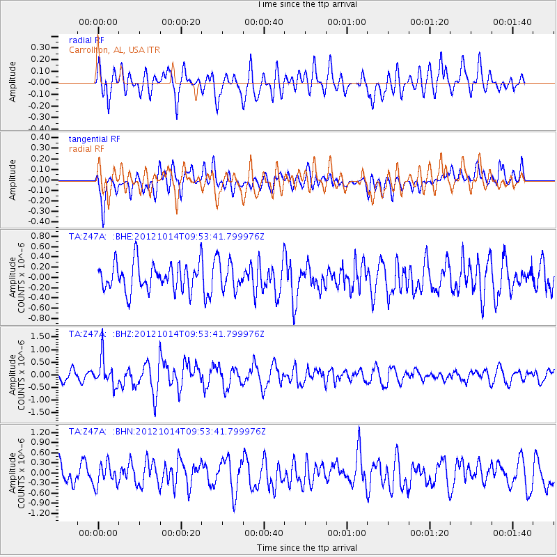
Z47A Carrollton, AL, USA - Earthquake Result Viewer
*The percent match for this event was below the threshold and hence no stack was calculated.
| Earthquake location: |
Kuril Islands |
| Earthquake latitude/longitude: |
48.3/154.4 |
| Earthquake time(UTC): |
2012/10/14 (288) 09:41:58 GMT |
| Earthquake Depth: |
35 km |
| Earthquake Magnitude: |
5.7 MB, 5.2 MS, 5.7 MW, 5.7 MW |
| Earthquake Catalog/Contributor: |
WHDF/NEIC |
|
| Network: |
TA USArray Transportable Network (new EarthScope stations) |
| Station: |
Z47A Carrollton, AL, USA |
| Lat/Lon: |
33.20 N/88.07 W |
| Elevation: |
65 m |
|
| Distance: |
81.5 deg |
| Az: |
48.755 deg |
| Baz: |
323.224 deg |
| Ray Param: |
$rayparam |
*The percent match for this event was below the threshold and hence was not used in the summary stack. |
|
| Radial Match: |
67.44182 % |
| Radial Bump: |
400 |
| Transverse Match: |
53.395496 % |
| Transverse Bump: |
400 |
| SOD ConfigId: |
478790 |
| Insert Time: |
2013-02-23 03:54:04.884 +0000 |
| GWidth: |
2.5 |
| Max Bumps: |
400 |
| Tol: |
0.001 |
|
Signal To Noise
| Channel | StoN | STA | LTA |
| TA:Z47A: :BHZ:20121014T09:53:41.799976Z | 1.9320214 | 5.6981764E-7 | 2.9493341E-7 |
| TA:Z47A: :BHN:20121014T09:53:41.799976Z | 1.0825841 | 3.2576486E-7 | 3.0091414E-7 |
| TA:Z47A: :BHE:20121014T09:53:41.799976Z | 0.9863895 | 2.618853E-7 | 2.6549887E-7 |
| Arrivals |
| Ps | |
| PpPs | |
| PsPs/PpSs | |


