You are here: Home > Network List > TA - USArray Transportable Network (new EarthScope stations) Stations List
> Station 121A Cookes Peak, Deming, NM, USA > Earthquake Result Viewer
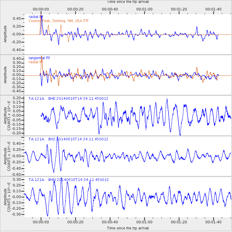
121A Cookes Peak, Deming, NM, USA - Earthquake Result Viewer
*The percent match for this event was below the threshold and hence no stack was calculated.
| Earthquake location: |
Jan Mayen Island Region |
| Earthquake latitude/longitude: |
70.4/-15.2 |
| Earthquake time(UTC): |
2014/06/16 (167) 14:24:31 GMT |
| Earthquake Depth: |
11 km |
| Earthquake Magnitude: |
5.5 MW |
| Earthquake Catalog/Contributor: |
ISC/ISC |
|
| Network: |
TA USArray Transportable Network (new EarthScope stations) |
| Station: |
121A Cookes Peak, Deming, NM, USA |
| Lat/Lon: |
32.53 N/107.79 W |
| Elevation: |
1652 m |
|
| Distance: |
60.6 deg |
| Az: |
284.413 deg |
| Baz: |
22.793 deg |
| Ray Param: |
$rayparam |
*The percent match for this event was below the threshold and hence was not used in the summary stack. |
|
| Radial Match: |
66.81368 % |
| Radial Bump: |
335 |
| Transverse Match: |
59.98663 % |
| Transverse Bump: |
400 |
| SOD ConfigId: |
3390531 |
| Insert Time: |
2019-04-12 07:53:13.782 +0000 |
| GWidth: |
2.5 |
| Max Bumps: |
400 |
| Tol: |
0.001 |
|
Signal To Noise
| Channel | StoN | STA | LTA |
| TA:121A: :BHZ:20140616T14:34:11.45001Z | 1.9541768 | 1.4734383E-7 | 7.5399434E-8 |
| TA:121A: :BHN:20140616T14:34:11.45001Z | 3.2274854 | 1.4790314E-7 | 4.582612E-8 |
| TA:121A: :BHE:20140616T14:34:11.45001Z | 1.7153875 | 9.3832014E-8 | 5.470019E-8 |
| Arrivals |
| Ps | |
| PpPs | |
| PsPs/PpSs | |


