You are here: Home > Network List > CI - Caltech Regional Seismic Network Stations List
> Station SNCC San Nicolas Island, , CA, USA > Earthquake Result Viewer
SNCC San Nicolas Island, , CA, USA - Earthquake Result Viewer
| Earthquake location: |
East Of Kuril Islands |
| Earthquake latitude/longitude: |
46.2/154.5 |
| Earthquake time(UTC): |
2007/01/13 (013) 04:23:21 GMT |
| Earthquake Depth: |
10 km |
| Earthquake Magnitude: |
7.3 MB, 8.2 MS, 8.1 MW, 7.9 MW |
| Earthquake Catalog/Contributor: |
WHDF/NEIC |
|
| Network: |
CI Caltech Regional Seismic Network |
| Station: |
SNCC San Nicolas Island, , CA, USA |
| Lat/Lon: |
33.25 N/119.52 W |
| Elevation: |
275 m |
|
| Distance: |
64.3 deg |
| Az: |
68.094 deg |
| Baz: |
309.789 deg |
| Ray Param: |
0.05902124 |
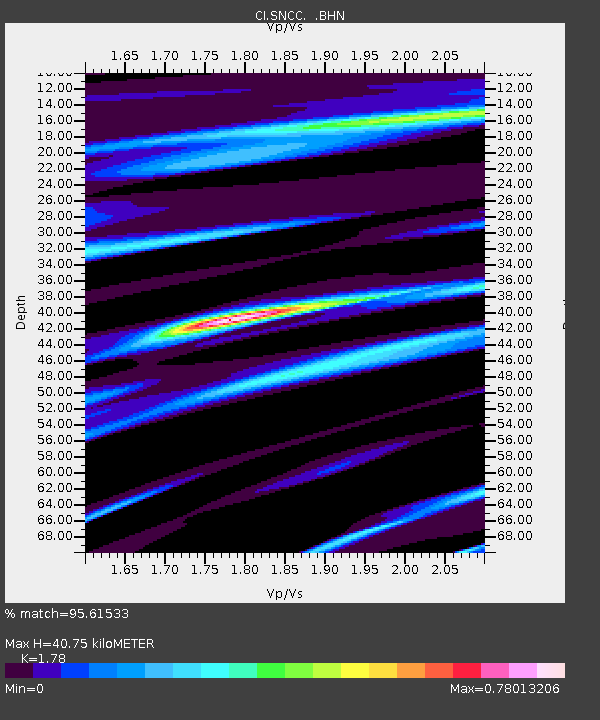
| Estimated Moho Depth: |
40.75 km |
| Estimated Crust Vp/Vs: |
1.78 |
| Assumed Crust Vp: |
6.048 km/s |
| Estimated Crust Vs: |
3.398 km/s |
| Estimated Crust Poisson's Ratio: |
0.27 |
|
| Radial Match: |
95.61533 % |
| Radial Bump: |
342 |
| Transverse Match: |
89.89827 % |
| Transverse Bump: |
400 |
| SOD ConfigId: |
2564 |
| Insert Time: |
2010-02-25 20:25:26.963 +0000 |
| GWidth: |
2.5 |
| Max Bumps: |
400 |
| Tol: |
0.001 |
|

Signal To Noise
| Channel | StoN | STA | LTA |
| CI:SNCC: :BHN:20070113T04:33:25.375027Z | 2.1486323 | 1.5791212E-6 | 7.349425E-7 |
| CI:SNCC: :BHE:20070113T04:33:25.375027Z | 2.0771189 | 1.1950743E-6 | 5.753519E-7 |
| CI:SNCC: :BHZ:20070113T04:33:25.375027Z | 5.9968414 | 3.0489448E-6 | 5.084251E-7 |
| Arrivals |
| Ps | 5.5 SECOND |
| PpPs | 18 SECOND |
| PsPs/PpSs | 23 SECOND |


