You are here: Home > Network List > TA - USArray Transportable Network (new EarthScope stations) Stations List
> Station K40A Colesburg, IA, USA > Earthquake Result Viewer
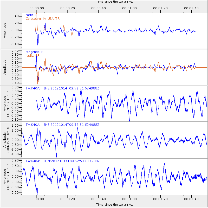
K40A Colesburg, IA, USA - Earthquake Result Viewer
*The percent match for this event was below the threshold and hence no stack was calculated.
| Earthquake location: |
Kuril Islands |
| Earthquake latitude/longitude: |
48.3/154.4 |
| Earthquake time(UTC): |
2012/10/14 (288) 09:41:58 GMT |
| Earthquake Depth: |
35 km |
| Earthquake Magnitude: |
5.7 MB, 5.2 MS, 5.7 MW, 5.7 MW |
| Earthquake Catalog/Contributor: |
WHDF/NEIC |
|
| Network: |
TA USArray Transportable Network (new EarthScope stations) |
| Station: |
K40A Colesburg, IA, USA |
| Lat/Lon: |
42.70 N/91.14 W |
| Elevation: |
274 m |
|
| Distance: |
72.6 deg |
| Az: |
44.704 deg |
| Baz: |
320.427 deg |
| Ray Param: |
$rayparam |
*The percent match for this event was below the threshold and hence was not used in the summary stack. |
|
| Radial Match: |
52.670017 % |
| Radial Bump: |
400 |
| Transverse Match: |
74.98314 % |
| Transverse Bump: |
400 |
| SOD ConfigId: |
478790 |
| Insert Time: |
2013-02-23 03:55:23.971 +0000 |
| GWidth: |
2.5 |
| Max Bumps: |
400 |
| Tol: |
0.001 |
|
Signal To Noise
| Channel | StoN | STA | LTA |
| TA:K40A: :BHZ:20121014T09:52:51.624988Z | 1.6050093 | 7.4477686E-7 | 4.6403272E-7 |
| TA:K40A: :BHN:20121014T09:52:51.624988Z | 1.0910927 | 4.1568092E-7 | 3.8097673E-7 |
| TA:K40A: :BHE:20121014T09:52:51.624988Z | 1.1828945 | 2.743294E-7 | 2.3191367E-7 |
| Arrivals |
| Ps | |
| PpPs | |
| PsPs/PpSs | |


