You are here: Home > Network List > TA - USArray Transportable Network (new EarthScope stations) Stations List
> Station E42A Champion, MI, USA > Earthquake Result Viewer
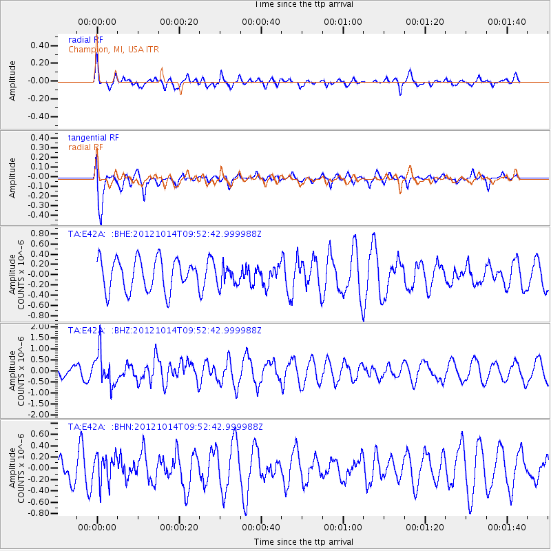
E42A Champion, MI, USA - Earthquake Result Viewer
*The percent match for this event was below the threshold and hence no stack was calculated.
| Earthquake location: |
Kuril Islands |
| Earthquake latitude/longitude: |
48.3/154.4 |
| Earthquake time(UTC): |
2012/10/14 (288) 09:41:58 GMT |
| Earthquake Depth: |
35 km |
| Earthquake Magnitude: |
5.7 MB, 5.2 MS, 5.7 MW, 5.7 MW |
| Earthquake Catalog/Contributor: |
WHDF/NEIC |
|
| Network: |
TA USArray Transportable Network (new EarthScope stations) |
| Station: |
E42A Champion, MI, USA |
| Lat/Lon: |
46.43 N/87.91 W |
| Elevation: |
475 m |
|
| Distance: |
71.1 deg |
| Az: |
40.347 deg |
| Baz: |
321.325 deg |
| Ray Param: |
$rayparam |
*The percent match for this event was below the threshold and hence was not used in the summary stack. |
|
| Radial Match: |
45.55154 % |
| Radial Bump: |
385 |
| Transverse Match: |
76.98521 % |
| Transverse Bump: |
396 |
| SOD ConfigId: |
478790 |
| Insert Time: |
2013-02-23 03:58:13.351 +0000 |
| GWidth: |
2.5 |
| Max Bumps: |
400 |
| Tol: |
0.001 |
|
Signal To Noise
| Channel | StoN | STA | LTA |
| TA:E42A: :BHZ:20121014T09:52:42.999988Z | 2.066539 | 7.6934884E-7 | 3.7228855E-7 |
| TA:E42A: :BHN:20121014T09:52:42.999988Z | 0.99745274 | 2.4526878E-7 | 2.4589514E-7 |
| TA:E42A: :BHE:20121014T09:52:42.999988Z | 0.609923 | 1.88553E-7 | 3.0914234E-7 |
| Arrivals |
| Ps | |
| PpPs | |
| PsPs/PpSs | |


