You are here: Home > Network List > TA - USArray Transportable Network (new EarthScope stations) Stations List
> Station E41A Kenton, MI, USA > Earthquake Result Viewer
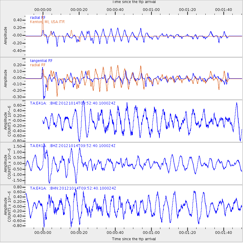
E41A Kenton, MI, USA - Earthquake Result Viewer
*The percent match for this event was below the threshold and hence no stack was calculated.
| Earthquake location: |
Kuril Islands |
| Earthquake latitude/longitude: |
48.3/154.4 |
| Earthquake time(UTC): |
2012/10/14 (288) 09:41:58 GMT |
| Earthquake Depth: |
35 km |
| Earthquake Magnitude: |
5.7 MB, 5.2 MS, 5.7 MW, 5.7 MW |
| Earthquake Catalog/Contributor: |
WHDF/NEIC |
|
| Network: |
TA USArray Transportable Network (new EarthScope stations) |
| Station: |
E41A Kenton, MI, USA |
| Lat/Lon: |
46.46 N/88.96 W |
| Elevation: |
377 m |
|
| Distance: |
70.7 deg |
| Az: |
40.921 deg |
| Baz: |
320.755 deg |
| Ray Param: |
$rayparam |
*The percent match for this event was below the threshold and hence was not used in the summary stack. |
|
| Radial Match: |
66.59488 % |
| Radial Bump: |
400 |
| Transverse Match: |
69.523 % |
| Transverse Bump: |
400 |
| SOD ConfigId: |
478790 |
| Insert Time: |
2013-02-23 03:58:15.078 +0000 |
| GWidth: |
2.5 |
| Max Bumps: |
400 |
| Tol: |
0.001 |
|
Signal To Noise
| Channel | StoN | STA | LTA |
| TA:E41A: :BHZ:20121014T09:52:40.100024Z | 3.3356814 | 1.0105781E-6 | 3.0296002E-7 |
| TA:E41A: :BHN:20121014T09:52:40.100024Z | 1.4127562 | 3.5970405E-7 | 2.5461154E-7 |
| TA:E41A: :BHE:20121014T09:52:40.100024Z | 0.83075935 | 2.6619142E-7 | 3.2041942E-7 |
| Arrivals |
| Ps | |
| PpPs | |
| PsPs/PpSs | |


