You are here: Home > Network List > G - GEOSCOPE Stations List
> Station WUS Wushi, Xinjiang Uygur, China > Earthquake Result Viewer
WUS Wushi, Xinjiang Uygur, China - Earthquake Result Viewer
| Earthquake location: |
Western Australia |
| Earthquake latitude/longitude: |
-16.0/124.3 |
| Earthquake time(UTC): |
1997/08/10 (222) 09:20:30 GMT |
| Earthquake Depth: |
10 km |
| Earthquake Magnitude: |
5.9 MB, 6.0 MS, 6.3 UNKNOWN, 6.3 MW |
| Earthquake Catalog/Contributor: |
WHDF/NEIC |
|
| Network: |
G GEOSCOPE |
| Station: |
WUS Wushi, Xinjiang Uygur, China |
| Lat/Lon: |
41.20 N/79.22 E |
| Elevation: |
1457 m |
|
| Distance: |
70.6 deg |
| Az: |
325.471 deg |
| Baz: |
133.749 deg |
| Ray Param: |
0.054879833 |
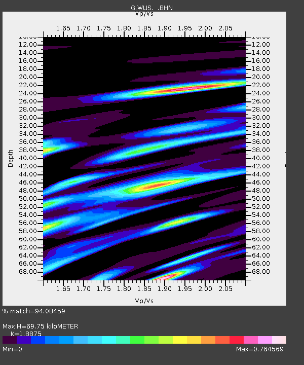
| Estimated Moho Depth: |
69.75 km |
| Estimated Crust Vp/Vs: |
1.89 |
| Assumed Crust Vp: |
6.353 km/s |
| Estimated Crust Vs: |
3.366 km/s |
| Estimated Crust Poisson's Ratio: |
0.30 |
|
| Radial Match: |
94.08459 % |
| Radial Bump: |
400 |
| Transverse Match: |
83.52004 % |
| Transverse Bump: |
400 |
| SOD ConfigId: |
6273 |
| Insert Time: |
2010-02-27 00:57:58.101 +0000 |
| GWidth: |
2.5 |
| Max Bumps: |
400 |
| Tol: |
0.001 |
|
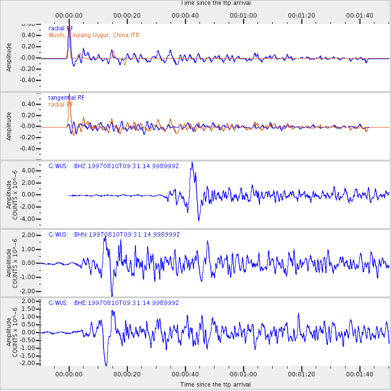
Signal To Noise
| Channel | StoN | STA | LTA |
| G:WUS: :BHN:19970810T09:31:14.998999Z | 2.291674 | 1.0181694E-7 | 4.4429065E-8 |
| G:WUS: :BHE:19970810T09:31:14.998999Z | 1.8465302 | 8.255546E-8 | 4.4708425E-8 |
| G:WUS: :BHZ:19970810T09:31:14.998999Z | 5.594552 | 3.0169636E-7 | 5.392681E-8 |
| Arrivals |
| Ps | 10 SECOND |
| PpPs | 31 SECOND |
| PsPs/PpSs | 41 SECOND |


