You are here: Home > Network List > TA - USArray Transportable Network (new EarthScope stations) Stations List
> Station 249A Camden, AL, USA > Earthquake Result Viewer
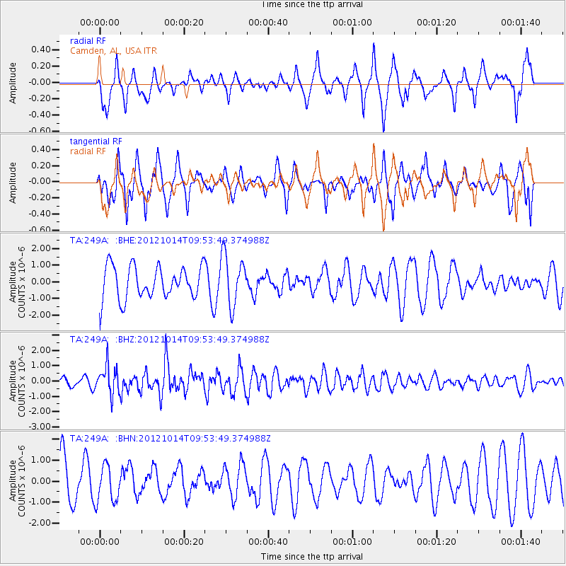
249A Camden, AL, USA - Earthquake Result Viewer
*The percent match for this event was below the threshold and hence no stack was calculated.
| Earthquake location: |
Kuril Islands |
| Earthquake latitude/longitude: |
48.3/154.4 |
| Earthquake time(UTC): |
2012/10/14 (288) 09:41:58 GMT |
| Earthquake Depth: |
35 km |
| Earthquake Magnitude: |
5.7 MB, 5.2 MS, 5.7 MW, 5.7 MW |
| Earthquake Catalog/Contributor: |
WHDF/NEIC |
|
| Network: |
TA USArray Transportable Network (new EarthScope stations) |
| Station: |
249A Camden, AL, USA |
| Lat/Lon: |
31.98 N/87.12 W |
| Elevation: |
66 m |
|
| Distance: |
83.0 deg |
| Az: |
48.839 deg |
| Baz: |
323.743 deg |
| Ray Param: |
$rayparam |
*The percent match for this event was below the threshold and hence was not used in the summary stack. |
|
| Radial Match: |
55.375263 % |
| Radial Bump: |
361 |
| Transverse Match: |
71.002304 % |
| Transverse Bump: |
400 |
| SOD ConfigId: |
478790 |
| Insert Time: |
2013-02-23 04:00:15.856 +0000 |
| GWidth: |
2.5 |
| Max Bumps: |
400 |
| Tol: |
0.001 |
|
Signal To Noise
| Channel | StoN | STA | LTA |
| TA:249A: :BHZ:20121014T09:53:49.374988Z | 2.771313 | 9.4388076E-7 | 3.4058974E-7 |
| TA:249A: :BHN:20121014T09:53:49.374988Z | 0.7280865 | 8.566043E-7 | 1.1765144E-6 |
| TA:249A: :BHE:20121014T09:53:49.374988Z | 1.5695235 | 1.5259363E-6 | 9.72229E-7 |
| Arrivals |
| Ps | |
| PpPs | |
| PsPs/PpSs | |


