You are here: Home > Network List > TA - USArray Transportable Network (new EarthScope stations) Stations List
> Station L46A Eue Claire, MI, USA > Earthquake Result Viewer
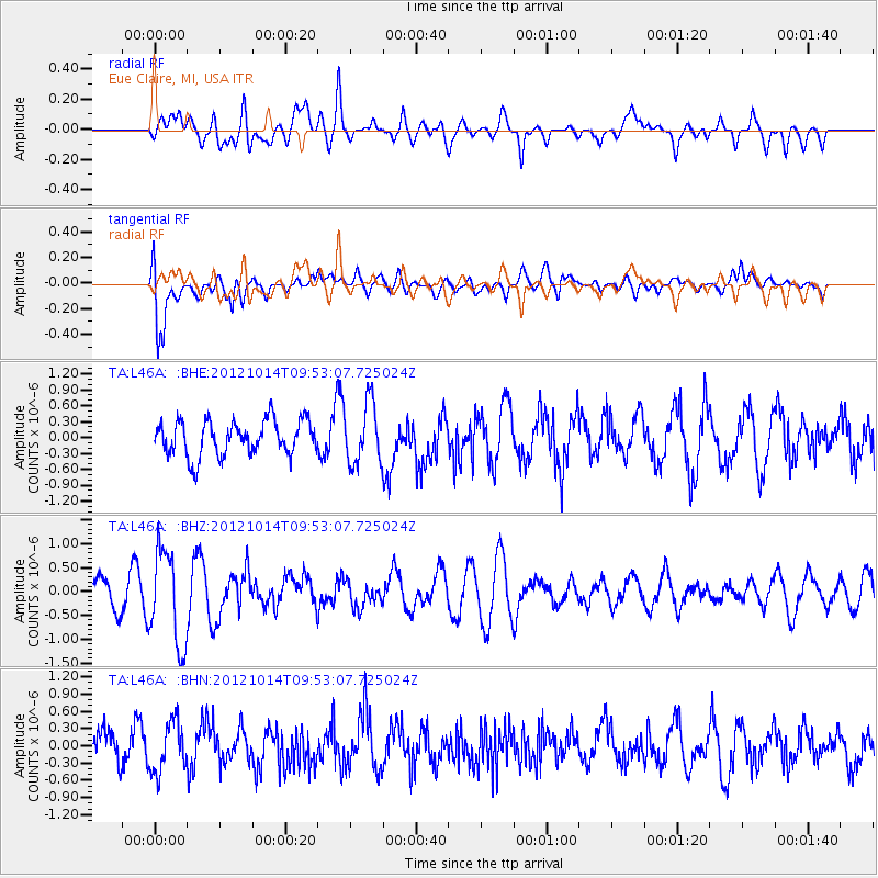
L46A Eue Claire, MI, USA - Earthquake Result Viewer
*The percent match for this event was below the threshold and hence no stack was calculated.
| Earthquake location: |
Kuril Islands |
| Earthquake latitude/longitude: |
48.3/154.4 |
| Earthquake time(UTC): |
2012/10/14 (288) 09:41:58 GMT |
| Earthquake Depth: |
35 km |
| Earthquake Magnitude: |
5.7 MB, 5.2 MS, 5.7 MW, 5.7 MW |
| Earthquake Catalog/Contributor: |
WHDF/NEIC |
|
| Network: |
TA USArray Transportable Network (new EarthScope stations) |
| Station: |
L46A Eue Claire, MI, USA |
| Lat/Lon: |
42.01 N/86.30 W |
| Elevation: |
223 m |
|
| Distance: |
75.3 deg |
| Az: |
42.216 deg |
| Baz: |
322.991 deg |
| Ray Param: |
$rayparam |
*The percent match for this event was below the threshold and hence was not used in the summary stack. |
|
| Radial Match: |
60.556126 % |
| Radial Bump: |
400 |
| Transverse Match: |
75.54837 % |
| Transverse Bump: |
400 |
| SOD ConfigId: |
478790 |
| Insert Time: |
2013-02-23 04:02:31.350 +0000 |
| GWidth: |
2.5 |
| Max Bumps: |
400 |
| Tol: |
0.001 |
|
Signal To Noise
| Channel | StoN | STA | LTA |
| TA:L46A: :BHZ:20121014T09:53:07.725024Z | 3.3740206 | 9.844009E-7 | 2.9175902E-7 |
| TA:L46A: :BHN:20121014T09:53:07.725024Z | 1.5056912 | 4.3736324E-7 | 2.9047342E-7 |
| TA:L46A: :BHE:20121014T09:53:07.725024Z | 1.7300117 | 5.6621025E-7 | 3.2728695E-7 |
| Arrivals |
| Ps | |
| PpPs | |
| PsPs/PpSs | |


