You are here: Home > Network List > TA - USArray Transportable Network (new EarthScope stations) Stations List
> Station M51A Elyria, OH, USA > Earthquake Result Viewer
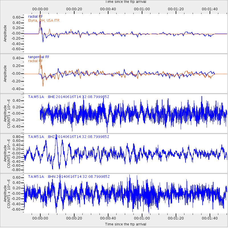
M51A Elyria, OH, USA - Earthquake Result Viewer
*The percent match for this event was below the threshold and hence no stack was calculated.
| Earthquake location: |
Jan Mayen Island Region |
| Earthquake latitude/longitude: |
70.4/-15.2 |
| Earthquake time(UTC): |
2014/06/16 (167) 14:24:31 GMT |
| Earthquake Depth: |
11 km |
| Earthquake Magnitude: |
5.5 MW |
| Earthquake Catalog/Contributor: |
ISC/ISC |
|
| Network: |
TA USArray Transportable Network (new EarthScope stations) |
| Station: |
M51A Elyria, OH, USA |
| Lat/Lon: |
41.33 N/82.18 W |
| Elevation: |
239 m |
|
| Distance: |
44.1 deg |
| Az: |
265.488 deg |
| Baz: |
26.569 deg |
| Ray Param: |
$rayparam |
*The percent match for this event was below the threshold and hence was not used in the summary stack. |
|
| Radial Match: |
63.67293 % |
| Radial Bump: |
400 |
| Transverse Match: |
68.87832 % |
| Transverse Bump: |
400 |
| SOD ConfigId: |
3390531 |
| Insert Time: |
2019-04-12 07:54:09.161 +0000 |
| GWidth: |
2.5 |
| Max Bumps: |
400 |
| Tol: |
0.001 |
|
Signal To Noise
| Channel | StoN | STA | LTA |
| TA:M51A: :BHZ:20140616T14:32:08.799985Z | 2.1352336 | 2.8769486E-7 | 1.3473695E-7 |
| TA:M51A: :BHN:20140616T14:32:08.799985Z | 1.0279044 | 1.9412992E-7 | 1.888599E-7 |
| TA:M51A: :BHE:20140616T14:32:08.799985Z | 0.9898419 | 1.5376338E-7 | 1.5534135E-7 |
| Arrivals |
| Ps | |
| PpPs | |
| PsPs/PpSs | |


