You are here: Home > Network List > TA - USArray Transportable Network (new EarthScope stations) Stations List
> Station MDND Maddock, ND, USA > Earthquake Result Viewer
MDND Maddock, ND, USA - Earthquake Result Viewer
| Earthquake location: |
Jan Mayen Island Region |
| Earthquake latitude/longitude: |
70.4/-15.2 |
| Earthquake time(UTC): |
2014/06/16 (167) 14:24:31 GMT |
| Earthquake Depth: |
11 km |
| Earthquake Magnitude: |
5.5 MW |
| Earthquake Catalog/Contributor: |
ISC/ISC |
|
| Network: |
TA USArray Transportable Network (new EarthScope stations) |
| Station: |
MDND Maddock, ND, USA |
| Lat/Lon: |
47.85 N/99.60 W |
| Elevation: |
479 m |
|
| Distance: |
44.1 deg |
| Az: |
285.669 deg |
| Baz: |
28.881 deg |
| Ray Param: |
0.07210526 |
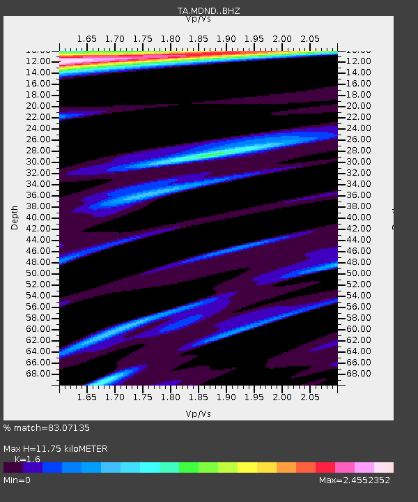
| Estimated Moho Depth: |
11.75 km |
| Estimated Crust Vp/Vs: |
1.60 |
| Assumed Crust Vp: |
6.53 km/s |
| Estimated Crust Vs: |
4.082 km/s |
| Estimated Crust Poisson's Ratio: |
0.18 |
|
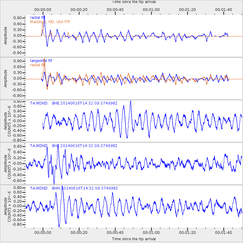
| Radial Match: |
83.07135 % |
| Radial Bump: |
359 |
| Transverse Match: |
57.54343 % |
| Transverse Bump: |
400 |
| SOD ConfigId: |
3390531 |
| Insert Time: |
2019-04-12 07:54:16.158 +0000 |
| GWidth: |
2.5 |
| Max Bumps: |
400 |
| Tol: |
0.001 |
|
Signal To Noise
| Channel | StoN | STA | LTA |
| TA:MDND: :BHZ:20140616T14:32:09.374998Z | 3.7307017 | 2.6102813E-7 | 6.996757E-8 |
| TA:MDND: :BHN:20140616T14:32:09.374998Z | 0.43126228 | 1.1701557E-7 | 2.713327E-7 |
| TA:MDND: :BHE:20140616T14:32:09.374998Z | 1.4098612 | 2.6354428E-7 | 1.8692924E-7 |
| Arrivals |
| Ps | 1.2 SECOND |
| PpPs | 4.3 SECOND |
| PsPs/PpSs | 5.5 SECOND |


