You are here: Home > Network List > CN - Canadian National Seismograph Network Stations List
> Station INK INUVIK, NT > Earthquake Result Viewer
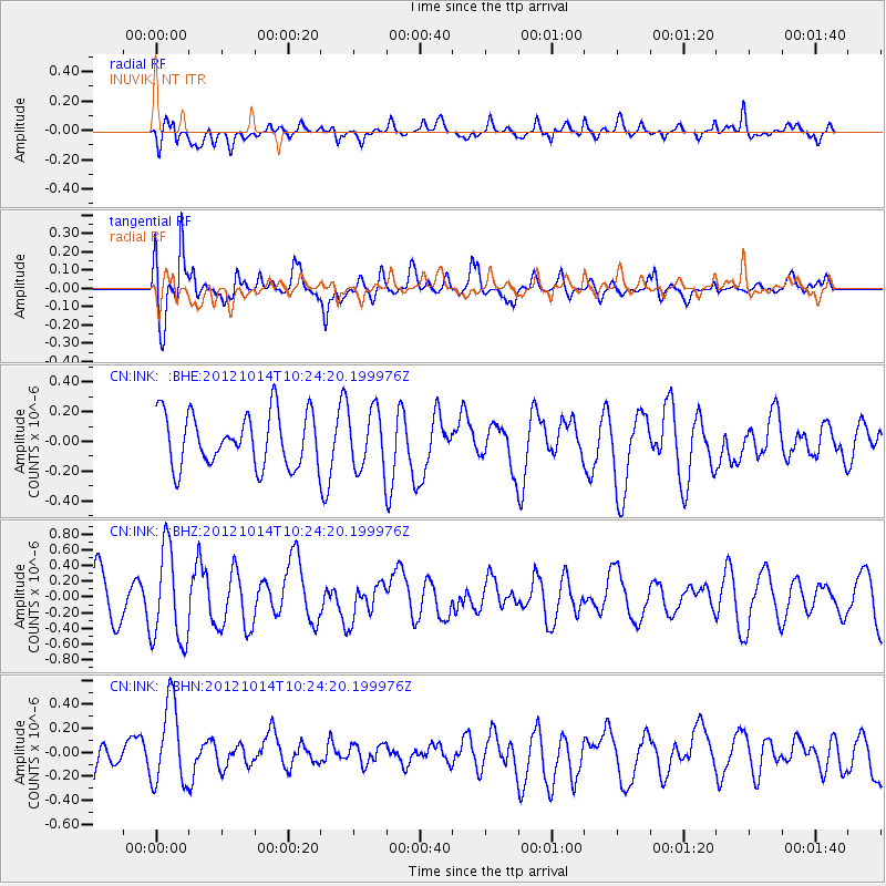
INK INUVIK, NT - Earthquake Result Viewer
*The percent match for this event was below the threshold and hence no stack was calculated.
| Earthquake location: |
Eastern Caucasus |
| Earthquake latitude/longitude: |
41.8/46.4 |
| Earthquake time(UTC): |
2012/10/14 (288) 10:13:38 GMT |
| Earthquake Depth: |
10 km |
| Earthquake Magnitude: |
5.5 MW, 5.4 MS, 5.3 MB, 5.6 ML |
| Earthquake Catalog/Contributor: |
WHDF/NEIC |
|
| Network: |
CN Canadian National Seismograph Network |
| Station: |
INK INUVIK, NT |
| Lat/Lon: |
68.31 N/133.53 W |
| Elevation: |
44 m |
|
| Distance: |
70.2 deg |
| Az: |
359.972 deg |
| Baz: |
0.055 deg |
| Ray Param: |
$rayparam |
*The percent match for this event was below the threshold and hence was not used in the summary stack. |
|
| Radial Match: |
61.77953 % |
| Radial Bump: |
400 |
| Transverse Match: |
79.04678 % |
| Transverse Bump: |
400 |
| SOD ConfigId: |
478790 |
| Insert Time: |
2013-02-23 04:07:36.397 +0000 |
| GWidth: |
2.5 |
| Max Bumps: |
400 |
| Tol: |
0.001 |
|
Signal To Noise
| Channel | StoN | STA | LTA |
| CN:INK: :BHZ:20121014T10:24:20.199976Z | 2.1893528 | 5.98159E-7 | 2.732127E-7 |
| CN:INK: :BHN:20121014T10:24:20.199976Z | 2.5577936 | 3.4805163E-7 | 1.3607495E-7 |
| CN:INK: :BHE:20121014T10:24:20.199976Z | 1.1249214 | 1.9997182E-7 | 1.7776514E-7 |
| Arrivals |
| Ps | |
| PpPs | |
| PsPs/PpSs | |


