You are here: Home > Network List > G - GEOSCOPE Stations List
> Station WUS Wushi, Xinjiang Uygur, China > Earthquake Result Viewer
WUS Wushi, Xinjiang Uygur, China - Earthquake Result Viewer
| Earthquake location: |
Near East Coast Of Honshu, Japan |
| Earthquake latitude/longitude: |
35.4/140.5 |
| Earthquake time(UTC): |
1998/06/14 (165) 13:17:08 GMT |
| Earthquake Depth: |
45 km |
| Earthquake Magnitude: |
5.5 MB, 5.3 MS, 5.8 UNKNOWN, 5.8 MW |
| Earthquake Catalog/Contributor: |
WHDF/NEIC |
|
| Network: |
G GEOSCOPE |
| Station: |
WUS Wushi, Xinjiang Uygur, China |
| Lat/Lon: |
41.20 N/79.22 E |
| Elevation: |
1457 m |
|
| Distance: |
47.6 deg |
| Az: |
296.319 deg |
| Baz: |
76.102 deg |
| Ray Param: |
0.069777526 |
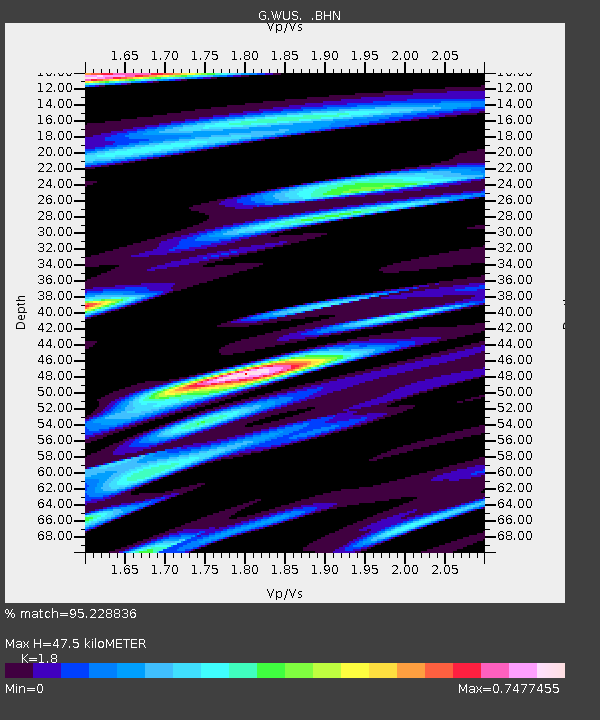
| Estimated Moho Depth: |
47.5 km |
| Estimated Crust Vp/Vs: |
1.80 |
| Assumed Crust Vp: |
6.353 km/s |
| Estimated Crust Vs: |
3.529 km/s |
| Estimated Crust Poisson's Ratio: |
0.28 |
|
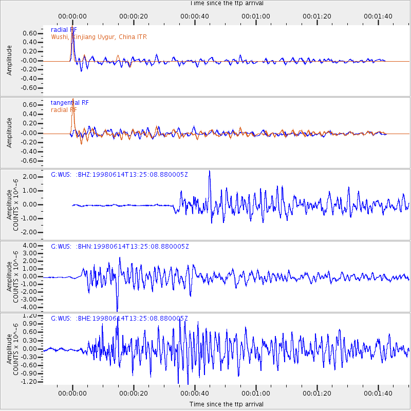
| Radial Match: |
95.228836 % |
| Radial Bump: |
400 |
| Transverse Match: |
87.96022 % |
| Transverse Bump: |
400 |
| SOD ConfigId: |
4480 |
| Insert Time: |
2010-02-27 00:58:25.715 +0000 |
| GWidth: |
2.5 |
| Max Bumps: |
400 |
| Tol: |
0.001 |
|
Signal To Noise
| Channel | StoN | STA | LTA |
| G:WUS: :BHN:19980614T13:25:08.880005Z | 11.878648 | 4.2738392E-7 | 3.597917E-8 |
| G:WUS: :BHE:19980614T13:25:08.880005Z | 1.0093094 | 4.6216154E-8 | 4.5789882E-8 |
| G:WUS: :BHZ:19980614T13:25:08.880005Z | 8.431112 | 2.3321958E-7 | 2.7661782E-8 |
| Arrivals |
| Ps | 6.3 SECOND |
| PpPs | 20 SECOND |
| PsPs/PpSs | 26 SECOND |


