You are here: Home > Network List > GT - Global Telemetered Seismograph Network (USAF/USGS) Stations List
> Station PLCA Paso Flores, Argentina > Earthquake Result Viewer
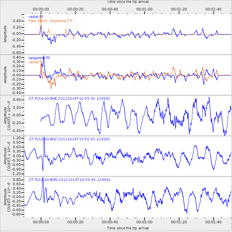
PLCA Paso Flores, Argentina - Earthquake Result Viewer
*The percent match for this event was below the threshold and hence no stack was calculated.
| Earthquake location: |
Near Coast Of Chiapas, Mexico |
| Earthquake latitude/longitude: |
14.7/-92.3 |
| Earthquake time(UTC): |
2012/10/14 (288) 10:41:23 GMT |
| Earthquake Depth: |
69 km |
| Earthquake Magnitude: |
5.5 MW, 5.4 MB, 5.2 MD |
| Earthquake Catalog/Contributor: |
WHDF/NEIC |
|
| Network: |
GT Global Telemetered Seismograph Network (USAF/USGS) |
| Station: |
PLCA Paso Flores, Argentina |
| Lat/Lon: |
40.73 S/70.55 W |
| Elevation: |
1050 m |
|
| Distance: |
58.7 deg |
| Az: |
160.77 deg |
| Baz: |
335.201 deg |
| Ray Param: |
$rayparam |
*The percent match for this event was below the threshold and hence was not used in the summary stack. |
|
| Radial Match: |
70.888855 % |
| Radial Bump: |
400 |
| Transverse Match: |
69.715744 % |
| Transverse Bump: |
400 |
| SOD ConfigId: |
478790 |
| Insert Time: |
2013-02-23 04:17:09.247 +0000 |
| GWidth: |
2.5 |
| Max Bumps: |
400 |
| Tol: |
0.001 |
|
Signal To Noise
| Channel | StoN | STA | LTA |
| GT:PLCA:00:BHZ:20121014T10:50:43.12499Z | 1.3373986 | 4.1674807E-7 | 3.1161096E-7 |
| GT:PLCA:00:BHN:20121014T10:50:43.12499Z | 1.9640038 | 3.3591976E-7 | 1.7103824E-7 |
| GT:PLCA:00:BHE:20121014T10:50:43.12499Z | 1.4580793 | 2.5208413E-7 | 1.7288781E-7 |
| Arrivals |
| Ps | |
| PpPs | |
| PsPs/PpSs | |


