You are here: Home > Network List > TA - USArray Transportable Network (new EarthScope stations) Stations List
> Station V54A Nebo, NC, USA > Earthquake Result Viewer
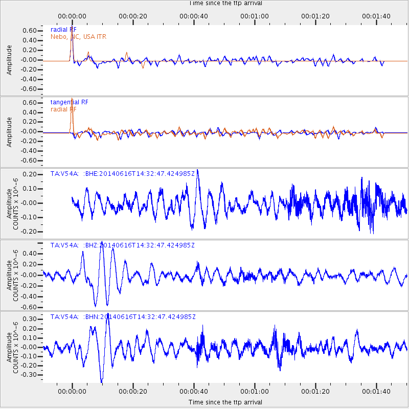
V54A Nebo, NC, USA - Earthquake Result Viewer

| Earthquake location: |
Jan Mayen Island Region |
| Earthquake latitude/longitude: |
70.4/-15.2 |
| Earthquake time(UTC): |
2014/06/16 (167) 14:24:31 GMT |
| Earthquake Depth: |
11 km |
| Earthquake Magnitude: |
5.5 MW |
| Earthquake Catalog/Contributor: |
ISC/ISC |
|
| Network: |
TA USArray Transportable Network (new EarthScope stations) |
| Station: |
V54A Nebo, NC, USA |
| Lat/Lon: |
35.78 N/81.95 W |
| Elevation: |
448 m |
|
| Distance: |
49.0 deg |
| Az: |
261.977 deg |
| Baz: |
24.296 deg |
| Ray Param: |
0.06899209 |
| Estimated Moho Depth: |
55.0 km |
| Estimated Crust Vp/Vs: |
1.70 |
| Assumed Crust Vp: |
6.419 km/s |
| Estimated Crust Vs: |
3.782 km/s |
| Estimated Crust Poisson's Ratio: |
0.23 |
|
| Radial Match: |
81.995125 % |
| Radial Bump: |
385 |
| Transverse Match: |
60.208557 % |
| Transverse Bump: |
400 |
| SOD ConfigId: |
3390531 |
| Insert Time: |
2019-04-12 07:55:03.964 +0000 |
| GWidth: |
2.5 |
| Max Bumps: |
400 |
| Tol: |
0.001 |
|
Signal To Noise
| Channel | StoN | STA | LTA |
| TA:V54A: :BHZ:20140616T14:32:47.424985Z | 3.262511 | 1.6528368E-7 | 5.0661495E-8 |
| TA:V54A: :BHN:20140616T14:32:47.424985Z | 2.0951242 | 8.3179685E-8 | 3.9701554E-8 |
| TA:V54A: :BHE:20140616T14:32:47.424985Z | 1.2823436 | 5.827553E-8 | 4.544455E-8 |
| Arrivals |
| Ps | 6.4 SECOND |
| PpPs | 22 SECOND |
| PsPs/PpSs | 28 SECOND |


