You are here: Home > Network List > TA - USArray Transportable Network (new EarthScope stations) Stations List
> Station E42A Champion, MI, USA > Earthquake Result Viewer
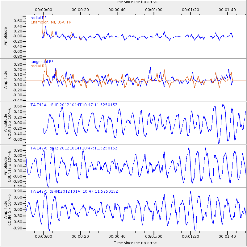
E42A Champion, MI, USA - Earthquake Result Viewer
*The percent match for this event was below the threshold and hence no stack was calculated.
| Earthquake location: |
Near Coast Of Chiapas, Mexico |
| Earthquake latitude/longitude: |
14.7/-92.3 |
| Earthquake time(UTC): |
2012/10/14 (288) 10:41:23 GMT |
| Earthquake Depth: |
69 km |
| Earthquake Magnitude: |
5.5 MW, 5.4 MB, 5.2 MD |
| Earthquake Catalog/Contributor: |
WHDF/NEIC |
|
| Network: |
TA USArray Transportable Network (new EarthScope stations) |
| Station: |
E42A Champion, MI, USA |
| Lat/Lon: |
46.43 N/87.91 W |
| Elevation: |
475 m |
|
| Distance: |
31.9 deg |
| Az: |
5.737 deg |
| Baz: |
188.04 deg |
| Ray Param: |
$rayparam |
*The percent match for this event was below the threshold and hence was not used in the summary stack. |
|
| Radial Match: |
72.80374 % |
| Radial Bump: |
400 |
| Transverse Match: |
52.72803 % |
| Transverse Bump: |
400 |
| SOD ConfigId: |
478790 |
| Insert Time: |
2013-02-23 04:19:07.333 +0000 |
| GWidth: |
2.5 |
| Max Bumps: |
400 |
| Tol: |
0.001 |
|
Signal To Noise
| Channel | StoN | STA | LTA |
| TA:E42A: :BHZ:20121014T10:47:11.525015Z | 2.6475801 | 7.6788234E-7 | 2.9003175E-7 |
| TA:E42A: :BHN:20121014T10:47:11.525015Z | 2.2359128 | 5.973129E-7 | 2.6714497E-7 |
| TA:E42A: :BHE:20121014T10:47:11.525015Z | 0.75890756 | 2.1520991E-7 | 2.8357854E-7 |
| Arrivals |
| Ps | |
| PpPs | |
| PsPs/PpSs | |


