You are here: Home > Network List > US - United States National Seismic Network Stations List
> Station MSO Missoula, Montana, USA > Earthquake Result Viewer
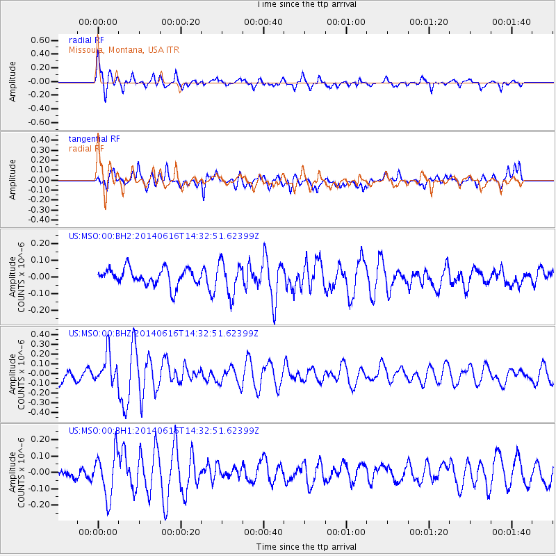
MSO Missoula, Montana, USA - Earthquake Result Viewer
*The percent match for this event was below the threshold and hence no stack was calculated.
| Earthquake location: |
Jan Mayen Island Region |
| Earthquake latitude/longitude: |
70.4/-15.2 |
| Earthquake time(UTC): |
2014/06/16 (167) 14:24:31 GMT |
| Earthquake Depth: |
11 km |
| Earthquake Magnitude: |
5.5 MW |
| Earthquake Catalog/Contributor: |
ISC/ISC |
|
| Network: |
US United States National Seismic Network |
| Station: |
MSO Missoula, Montana, USA |
| Lat/Lon: |
46.83 N/113.94 W |
| Elevation: |
1264 m |
|
| Distance: |
49.5 deg |
| Az: |
296.88 deg |
| Baz: |
26.036 deg |
| Ray Param: |
$rayparam |
*The percent match for this event was below the threshold and hence was not used in the summary stack. |
|
| Radial Match: |
65.72362 % |
| Radial Bump: |
395 |
| Transverse Match: |
69.39561 % |
| Transverse Bump: |
400 |
| SOD ConfigId: |
3390531 |
| Insert Time: |
2019-04-12 07:55:59.859 +0000 |
| GWidth: |
2.5 |
| Max Bumps: |
400 |
| Tol: |
0.001 |
|
Signal To Noise
| Channel | StoN | STA | LTA |
| US:MSO:00:BHZ:20140616T14:32:51.62399Z | 2.8547978 | 1.583021E-7 | 5.545125E-8 |
| US:MSO:00:BH1:20140616T14:32:51.62399Z | 3.3213012 | 1.4056023E-7 | 4.232083E-8 |
| US:MSO:00:BH2:20140616T14:32:51.62399Z | 1.9912614 | 9.9795024E-8 | 5.0116487E-8 |
| Arrivals |
| Ps | |
| PpPs | |
| PsPs/PpSs | |


