You are here: Home > Network List > IW - Intermountain West Stations List
> Station MOOW Moose Ponds, Wyoming, USA > Earthquake Result Viewer
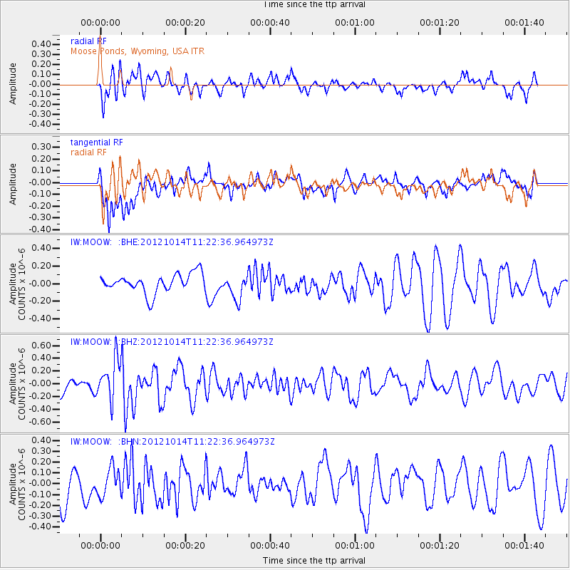
MOOW Moose Ponds, Wyoming, USA - Earthquake Result Viewer
*The percent match for this event was below the threshold and hence no stack was calculated.
| Earthquake location: |
Off East Coast Of Honshu, Japan |
| Earthquake latitude/longitude: |
38.2/144.3 |
| Earthquake time(UTC): |
2012/10/14 (288) 11:11:36 GMT |
| Earthquake Depth: |
34 km |
| Earthquake Magnitude: |
5.6 MB, 4.9 MS, 5.4 MW |
| Earthquake Catalog/Contributor: |
WHDF/NEIC |
|
| Network: |
IW Intermountain West |
| Station: |
MOOW Moose Ponds, Wyoming, USA |
| Lat/Lon: |
43.75 N/110.74 W |
| Elevation: |
2128 m |
|
| Distance: |
73.9 deg |
| Az: |
46.793 deg |
| Baz: |
307.603 deg |
| Ray Param: |
$rayparam |
*The percent match for this event was below the threshold and hence was not used in the summary stack. |
|
| Radial Match: |
47.91864 % |
| Radial Bump: |
400 |
| Transverse Match: |
47.599148 % |
| Transverse Bump: |
400 |
| SOD ConfigId: |
478790 |
| Insert Time: |
2013-02-23 04:27:59.514 +0000 |
| GWidth: |
2.5 |
| Max Bumps: |
400 |
| Tol: |
0.001 |
|
Signal To Noise
| Channel | StoN | STA | LTA |
| IW:MOOW: :BHZ:20121014T11:22:36.964973Z | 2.557416 | 3.264411E-7 | 1.276449E-7 |
| IW:MOOW: :BHN:20121014T11:22:36.964973Z | 0.7238665 | 1.3204932E-7 | 1.824222E-7 |
| IW:MOOW: :BHE:20121014T11:22:36.964973Z | 1.3350377 | 1.4418737E-7 | 1.0800247E-7 |
| Arrivals |
| Ps | |
| PpPs | |
| PsPs/PpSs | |


