You are here: Home > Network List > TA - USArray Transportable Network (new EarthScope stations) Stations List
> Station R42A Luebbering, MO, USA > Earthquake Result Viewer
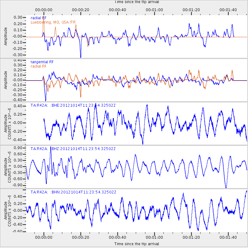
R42A Luebbering, MO, USA - Earthquake Result Viewer
*The percent match for this event was below the threshold and hence no stack was calculated.
| Earthquake location: |
Off East Coast Of Honshu, Japan |
| Earthquake latitude/longitude: |
38.2/144.3 |
| Earthquake time(UTC): |
2012/10/14 (288) 11:11:36 GMT |
| Earthquake Depth: |
34 km |
| Earthquake Magnitude: |
5.6 MB, 4.9 MS, 5.4 MW |
| Earthquake Catalog/Contributor: |
WHDF/NEIC |
|
| Network: |
TA USArray Transportable Network (new EarthScope stations) |
| Station: |
R42A Luebbering, MO, USA |
| Lat/Lon: |
38.28 N/90.79 W |
| Elevation: |
218 m |
|
| Distance: |
88.5 deg |
| Az: |
40.233 deg |
| Baz: |
319.724 deg |
| Ray Param: |
$rayparam |
*The percent match for this event was below the threshold and hence was not used in the summary stack. |
|
| Radial Match: |
56.76302 % |
| Radial Bump: |
400 |
| Transverse Match: |
55.02386 % |
| Transverse Bump: |
400 |
| SOD ConfigId: |
478790 |
| Insert Time: |
2013-02-23 04:35:27.511 +0000 |
| GWidth: |
2.5 |
| Max Bumps: |
400 |
| Tol: |
0.001 |
|
Signal To Noise
| Channel | StoN | STA | LTA |
| TA:R42A: :BHZ:20121014T11:23:54.32502Z | 1.6600933 | 4.1786163E-7 | 2.5170974E-7 |
| TA:R42A: :BHN:20121014T11:23:54.32502Z | 1.0565248 | 2.2313192E-7 | 2.1119422E-7 |
| TA:R42A: :BHE:20121014T11:23:54.32502Z | 1.031743 | 1.798134E-7 | 1.7428118E-7 |
| Arrivals |
| Ps | |
| PpPs | |
| PsPs/PpSs | |


