You are here: Home > Network List > TA - USArray Transportable Network (new EarthScope stations) Stations List
> Station H38A Maiden Rock, WI, USA > Earthquake Result Viewer
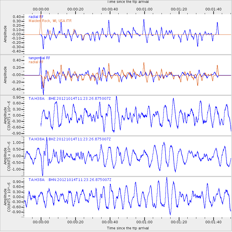
H38A Maiden Rock, WI, USA - Earthquake Result Viewer
*The percent match for this event was below the threshold and hence no stack was calculated.
| Earthquake location: |
Off East Coast Of Honshu, Japan |
| Earthquake latitude/longitude: |
38.2/144.3 |
| Earthquake time(UTC): |
2012/10/14 (288) 11:11:36 GMT |
| Earthquake Depth: |
34 km |
| Earthquake Magnitude: |
5.6 MB, 4.9 MS, 5.4 MW |
| Earthquake Catalog/Contributor: |
WHDF/NEIC |
|
| Network: |
TA USArray Transportable Network (new EarthScope stations) |
| Station: |
H38A Maiden Rock, WI, USA |
| Lat/Lon: |
44.68 N/92.28 W |
| Elevation: |
333 m |
|
| Distance: |
83.0 deg |
| Az: |
36.888 deg |
| Baz: |
318.493 deg |
| Ray Param: |
$rayparam |
*The percent match for this event was below the threshold and hence was not used in the summary stack. |
|
| Radial Match: |
65.19002 % |
| Radial Bump: |
400 |
| Transverse Match: |
78.14143 % |
| Transverse Bump: |
400 |
| SOD ConfigId: |
478790 |
| Insert Time: |
2013-02-23 04:35:47.344 +0000 |
| GWidth: |
2.5 |
| Max Bumps: |
400 |
| Tol: |
0.001 |
|
Signal To Noise
| Channel | StoN | STA | LTA |
| TA:H38A: :BHZ:20121014T11:23:26.875007Z | 1.9383553 | 7.1539785E-7 | 3.6907468E-7 |
| TA:H38A: :BHN:20121014T11:23:26.875007Z | 0.7825958 | 3.2421448E-7 | 4.1428086E-7 |
| TA:H38A: :BHE:20121014T11:23:26.875007Z | 0.7965517 | 2.5964167E-7 | 3.2595707E-7 |
| Arrivals |
| Ps | |
| PpPs | |
| PsPs/PpSs | |


