You are here: Home > Network List > TA - USArray Transportable Network (new EarthScope stations) Stations List
> Station N42A Yates City, IL, USA > Earthquake Result Viewer
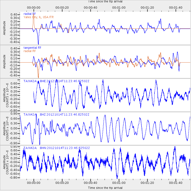
N42A Yates City, IL, USA - Earthquake Result Viewer
*The percent match for this event was below the threshold and hence no stack was calculated.
| Earthquake location: |
Off East Coast Of Honshu, Japan |
| Earthquake latitude/longitude: |
38.2/144.3 |
| Earthquake time(UTC): |
2012/10/14 (288) 11:11:36 GMT |
| Earthquake Depth: |
34 km |
| Earthquake Magnitude: |
5.6 MB, 4.9 MS, 5.4 MW |
| Earthquake Catalog/Contributor: |
WHDF/NEIC |
|
| Network: |
TA USArray Transportable Network (new EarthScope stations) |
| Station: |
N42A Yates City, IL, USA |
| Lat/Lon: |
40.83 N/90.03 W |
| Elevation: |
205 m |
|
| Distance: |
87.0 deg |
| Az: |
38.143 deg |
| Baz: |
320.124 deg |
| Ray Param: |
$rayparam |
*The percent match for this event was below the threshold and hence was not used in the summary stack. |
|
| Radial Match: |
56.781147 % |
| Radial Bump: |
400 |
| Transverse Match: |
57.549294 % |
| Transverse Bump: |
400 |
| SOD ConfigId: |
478790 |
| Insert Time: |
2013-02-23 04:35:53.446 +0000 |
| GWidth: |
2.5 |
| Max Bumps: |
400 |
| Tol: |
0.001 |
|
Signal To Noise
| Channel | StoN | STA | LTA |
| TA:N42A: :BHZ:20121014T11:23:46.82502Z | 1.2589717 | 5.5318253E-7 | 4.3939232E-7 |
| TA:N42A: :BHN:20121014T11:23:46.82502Z | 0.5949927 | 2.6375844E-7 | 4.4329695E-7 |
| TA:N42A: :BHE:20121014T11:23:46.82502Z | 1.2093542 | 5.0602097E-7 | 4.1842247E-7 |
| Arrivals |
| Ps | |
| PpPs | |
| PsPs/PpSs | |


