You are here: Home > Network List > TA - USArray Transportable Network (new EarthScope stations) Stations List
> Station T45A Paducah, KY, USA > Earthquake Result Viewer
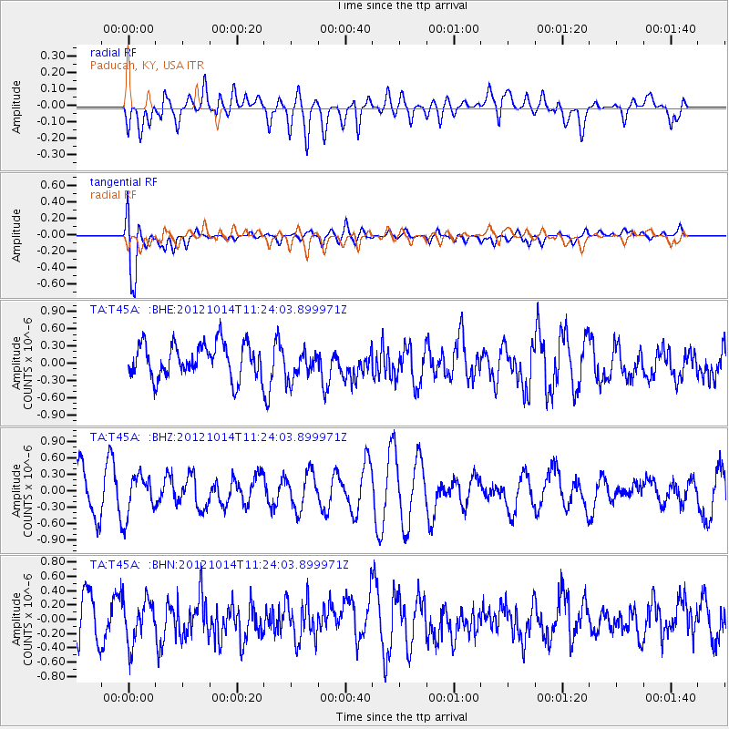
T45A Paducah, KY, USA - Earthquake Result Viewer
*The percent match for this event was below the threshold and hence no stack was calculated.
| Earthquake location: |
Off East Coast Of Honshu, Japan |
| Earthquake latitude/longitude: |
38.2/144.3 |
| Earthquake time(UTC): |
2012/10/14 (288) 11:11:36 GMT |
| Earthquake Depth: |
34 km |
| Earthquake Magnitude: |
5.6 MB, 4.9 MS, 5.4 MW |
| Earthquake Catalog/Contributor: |
WHDF/NEIC |
|
| Network: |
TA USArray Transportable Network (new EarthScope stations) |
| Station: |
T45A Paducah, KY, USA |
| Lat/Lon: |
37.02 N/88.64 W |
| Elevation: |
119 m |
|
| Distance: |
90.6 deg |
| Az: |
39.721 deg |
| Baz: |
321.028 deg |
| Ray Param: |
$rayparam |
*The percent match for this event was below the threshold and hence was not used in the summary stack. |
|
| Radial Match: |
42.138153 % |
| Radial Bump: |
400 |
| Transverse Match: |
78.88783 % |
| Transverse Bump: |
400 |
| SOD ConfigId: |
478790 |
| Insert Time: |
2013-02-23 04:37:05.270 +0000 |
| GWidth: |
2.5 |
| Max Bumps: |
400 |
| Tol: |
0.001 |
|
Signal To Noise
| Channel | StoN | STA | LTA |
| TA:T45A: :BHZ:20121014T11:24:03.899971Z | 0.86243683 | 3.6389997E-7 | 4.2194392E-7 |
| TA:T45A: :BHN:20121014T11:24:03.899971Z | 0.8250718 | 3.0066423E-7 | 3.6440977E-7 |
| TA:T45A: :BHE:20121014T11:24:03.899971Z | 0.9114118 | 2.6720926E-7 | 2.9318167E-7 |
| Arrivals |
| Ps | |
| PpPs | |
| PsPs/PpSs | |


