You are here: Home > Network List > UW - Pacific Northwest Regional Seismic Network Stations List
> Station HOOD Mt Hood Meadows, OR CREST BB SMO > Earthquake Result Viewer
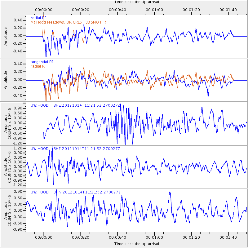
HOOD Mt Hood Meadows, OR CREST BB SMO - Earthquake Result Viewer
*The percent match for this event was below the threshold and hence no stack was calculated.
| Earthquake location: |
Off East Coast Of Honshu, Japan |
| Earthquake latitude/longitude: |
38.2/144.3 |
| Earthquake time(UTC): |
2012/10/14 (288) 11:11:36 GMT |
| Earthquake Depth: |
34 km |
| Earthquake Magnitude: |
5.6 MB, 4.9 MS, 5.4 MW |
| Earthquake Catalog/Contributor: |
WHDF/NEIC |
|
| Network: |
UW Pacific Northwest Regional Seismic Network |
| Station: |
HOOD Mt Hood Meadows, OR CREST BB SMO |
| Lat/Lon: |
45.32 N/121.65 W |
| Elevation: |
1520 m |
|
| Distance: |
66.6 deg |
| Az: |
50.09 deg |
| Baz: |
301.084 deg |
| Ray Param: |
$rayparam |
*The percent match for this event was below the threshold and hence was not used in the summary stack. |
|
| Radial Match: |
60.885605 % |
| Radial Bump: |
400 |
| Transverse Match: |
59.16606 % |
| Transverse Bump: |
400 |
| SOD ConfigId: |
478790 |
| Insert Time: |
2013-02-23 04:38:51.196 +0000 |
| GWidth: |
2.5 |
| Max Bumps: |
400 |
| Tol: |
0.001 |
|
Signal To Noise
| Channel | StoN | STA | LTA |
| UW:HOOD: :BHZ:20121014T11:21:52.270027Z | 2.2395475 | 6.222883E-7 | 2.7786342E-7 |
| UW:HOOD: :BHN:20121014T11:21:52.270027Z | 0.9298079 | 2.7745088E-7 | 2.9839592E-7 |
| UW:HOOD: :BHE:20121014T11:21:52.270027Z | 0.9712543 | 3.2587988E-7 | 3.3552476E-7 |
| Arrivals |
| Ps | |
| PpPs | |
| PsPs/PpSs | |


