You are here: Home > Network List > G - GEOSCOPE Stations List
> Station WUS Wushi, Xinjiang Uygur, China > Earthquake Result Viewer
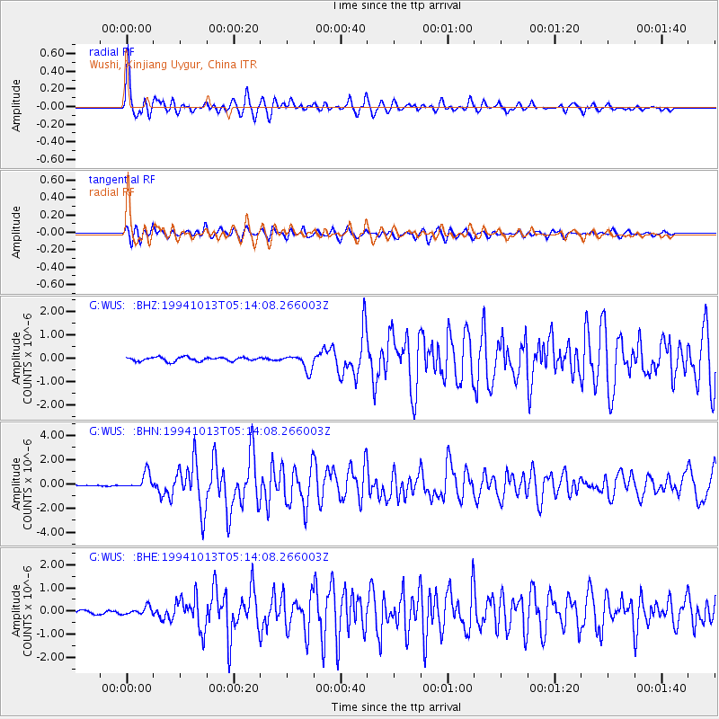
WUS Wushi, Xinjiang Uygur, China - Earthquake Result Viewer

| Earthquake location: |
Halmahera, Indonesia |
| Earthquake latitude/longitude: |
-1.2/127.9 |
| Earthquake time(UTC): |
1994/10/13 (286) 05:04:28 GMT |
| Earthquake Depth: |
33 km |
| Earthquake Magnitude: |
6.0 MB, 6.4 MS, 6.5 UNKNOWN, 6.4 MW |
| Earthquake Catalog/Contributor: |
WHDF/NEIC |
|
| Network: |
G GEOSCOPE |
| Station: |
WUS Wushi, Xinjiang Uygur, China |
| Lat/Lon: |
41.20 N/79.22 E |
| Elevation: |
1457 m |
|
| Distance: |
61.1 deg |
| Az: |
319.615 deg |
| Baz: |
120.861 deg |
| Ray Param: |
0.061046507 |
| Estimated Moho Depth: |
45.75 km |
| Estimated Crust Vp/Vs: |
1.90 |
| Assumed Crust Vp: |
6.353 km/s |
| Estimated Crust Vs: |
3.348 km/s |
| Estimated Crust Poisson's Ratio: |
0.31 |
|
| Radial Match: |
94.9143 % |
| Radial Bump: |
400 |
| Transverse Match: |
83.89688 % |
| Transverse Bump: |
400 |
| SOD ConfigId: |
4480 |
| Insert Time: |
2010-02-27 00:59:14.769 +0000 |
| GWidth: |
2.5 |
| Max Bumps: |
400 |
| Tol: |
0.001 |
|
Signal To Noise
| Channel | StoN | STA | LTA |
| G:WUS: :BHN:19941013T05:14:08.266003Z | 8.49289 | 6.796049E-7 | 8.0020456E-8 |
| G:WUS: :BHE:19941013T05:14:08.266003Z | 1.8615402 | 1.8085265E-7 | 9.715216E-8 |
| G:WUS: :BHZ:19941013T05:14:08.266003Z | 4.0714736 | 3.4472404E-7 | 8.466812E-8 |
| Arrivals |
| Ps | 6.7 SECOND |
| PpPs | 20 SECOND |
| PsPs/PpSs | 27 SECOND |


