You are here: Home > Network List > UW - Pacific Northwest Regional Seismic Network Stations List
> Station PASS Maple Falls, WA, USA > Earthquake Result Viewer
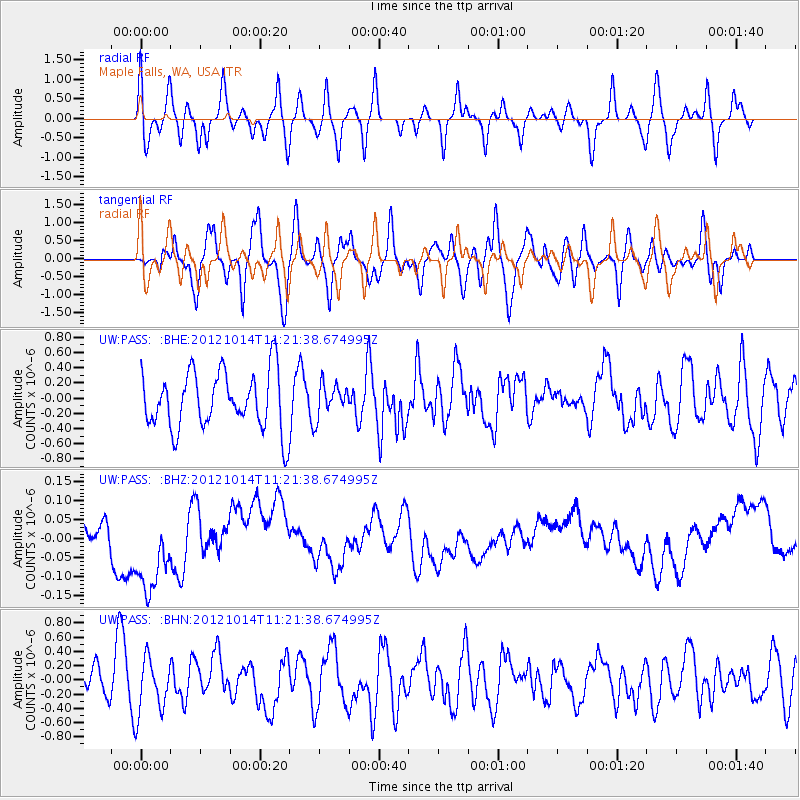
PASS Maple Falls, WA, USA - Earthquake Result Viewer
*The percent match for this event was below the threshold and hence no stack was calculated.
| Earthquake location: |
Off East Coast Of Honshu, Japan |
| Earthquake latitude/longitude: |
38.2/144.3 |
| Earthquake time(UTC): |
2012/10/14 (288) 11:11:36 GMT |
| Earthquake Depth: |
34 km |
| Earthquake Magnitude: |
5.6 MB, 4.9 MS, 5.4 MW |
| Earthquake Catalog/Contributor: |
WHDF/NEIC |
|
| Network: |
UW Pacific Northwest Regional Seismic Network |
| Station: |
PASS Maple Falls, WA, USA |
| Lat/Lon: |
49.00 N/122.09 W |
| Elevation: |
174 m |
|
| Distance: |
64.5 deg |
| Az: |
46.761 deg |
| Baz: |
299.387 deg |
| Ray Param: |
$rayparam |
*The percent match for this event was below the threshold and hence was not used in the summary stack. |
|
| Radial Match: |
44.097965 % |
| Radial Bump: |
400 |
| Transverse Match: |
45.84055 % |
| Transverse Bump: |
400 |
| SOD ConfigId: |
478790 |
| Insert Time: |
2013-02-23 04:39:20.424 +0000 |
| GWidth: |
2.5 |
| Max Bumps: |
400 |
| Tol: |
0.001 |
|
Signal To Noise
| Channel | StoN | STA | LTA |
| UW:PASS: :BHZ:20121014T11:21:38.674995Z | 0.7821996 | 8.242908E-8 | 1.0538113E-7 |
| UW:PASS: :BHN:20121014T11:21:38.674995Z | 1.2659717 | 3.771849E-7 | 2.9794103E-7 |
| UW:PASS: :BHE:20121014T11:21:38.674995Z | 0.57401097 | 2.1636829E-7 | 3.7694105E-7 |
| Arrivals |
| Ps | |
| PpPs | |
| PsPs/PpSs | |


