You are here: Home > Network List > AZ - ANZA Regional Network Stations List
> Station KNW AZ.KNW > Earthquake Result Viewer
KNW AZ.KNW - Earthquake Result Viewer
*The percent match for this event was below the threshold and hence no stack was calculated.
| Earthquake location: |
Kuril Islands |
| Earthquake latitude/longitude: |
49.6/156.4 |
| Earthquake time(UTC): |
2012/10/16 (290) 12:41:25 GMT |
| Earthquake Depth: |
81 km |
| Earthquake Magnitude: |
6.2 MB, 5.6 MW, 5.6 MW |
| Earthquake Catalog/Contributor: |
WHDF/NEIC |
|
| Network: |
AZ ANZA Regional Network |
| Station: |
KNW AZ.KNW |
| Lat/Lon: |
33.71 N/116.71 W |
| Elevation: |
1507 m |
|
| Distance: |
63.3 deg |
| Az: |
68.697 deg |
| Baz: |
313.366 deg |
| Ray Param: |
$rayparam |
*The percent match for this event was below the threshold and hence was not used in the summary stack. |
|
| Radial Match: |
51.245632 % |
| Radial Bump: |
400 |
| Transverse Match: |
58.87905 % |
| Transverse Bump: |
400 |
| SOD ConfigId: |
478790 |
| Insert Time: |
2013-02-23 04:50:33.498 +0000 |
| GWidth: |
2.5 |
| Max Bumps: |
400 |
| Tol: |
0.001 |
|
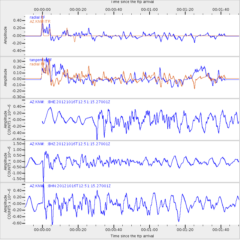
Signal To Noise
| Channel | StoN | STA | LTA |
| AZ:KNW: :BHZ:20121016T12:51:15.27001Z | 3.1846812 | 6.2034746E-7 | 1.9479107E-7 |
| AZ:KNW: :BHN:20121016T12:51:15.27001Z | 1.67779 | 2.3728633E-7 | 1.414279E-7 |
| AZ:KNW: :BHE:20121016T12:51:15.27001Z | 2.1170988 | 2.8223587E-7 | 1.3331257E-7 |
| Arrivals |
| Ps | |
| PpPs | |
| PsPs/PpSs | |


