You are here: Home > Network List > AZ - ANZA Regional Network Stations List
> Station FRD AZ.FRD > Earthquake Result Viewer
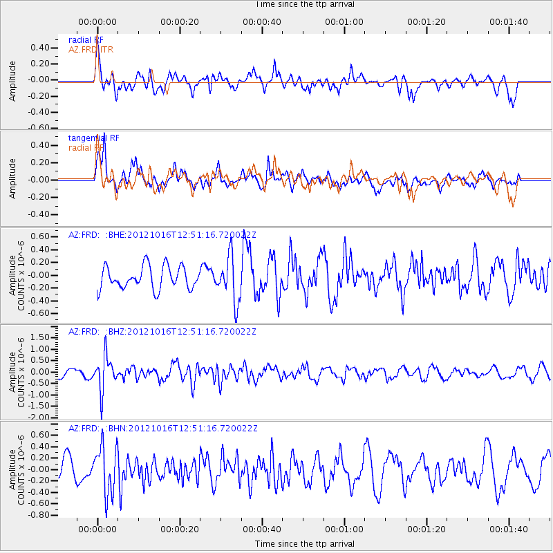
FRD AZ.FRD - Earthquake Result Viewer
*The percent match for this event was below the threshold and hence no stack was calculated.
| Earthquake location: |
Kuril Islands |
| Earthquake latitude/longitude: |
49.6/156.4 |
| Earthquake time(UTC): |
2012/10/16 (290) 12:41:25 GMT |
| Earthquake Depth: |
81 km |
| Earthquake Magnitude: |
6.2 MB, 5.6 MW, 5.6 MW |
| Earthquake Catalog/Contributor: |
WHDF/NEIC |
|
| Network: |
AZ ANZA Regional Network |
| Station: |
FRD AZ.FRD |
| Lat/Lon: |
33.49 N/116.60 W |
| Elevation: |
1164 m |
|
| Distance: |
63.5 deg |
| Az: |
68.804 deg |
| Baz: |
313.475 deg |
| Ray Param: |
$rayparam |
*The percent match for this event was below the threshold and hence was not used in the summary stack. |
|
| Radial Match: |
55.69812 % |
| Radial Bump: |
400 |
| Transverse Match: |
72.34804 % |
| Transverse Bump: |
400 |
| SOD ConfigId: |
478790 |
| Insert Time: |
2013-02-23 04:50:45.380 +0000 |
| GWidth: |
2.5 |
| Max Bumps: |
400 |
| Tol: |
0.001 |
|
Signal To Noise
| Channel | StoN | STA | LTA |
| AZ:FRD: :BHZ:20121016T12:51:16.720022Z | 4.2266436 | 7.596019E-7 | 1.7971753E-7 |
| AZ:FRD: :BHN:20121016T12:51:16.720022Z | 1.8013563 | 4.2892307E-7 | 2.3811117E-7 |
| AZ:FRD: :BHE:20121016T12:51:16.720022Z | 2.0841205 | 3.672711E-7 | 1.7622354E-7 |
| Arrivals |
| Ps | |
| PpPs | |
| PsPs/PpSs | |


