You are here: Home > Network List > BK - Berkeley Digital Seismograph Network Stations List
> Station HUMO Hull Mountain, OR > Earthquake Result Viewer
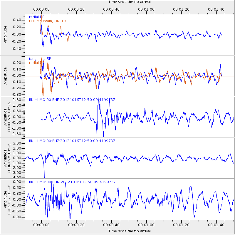
HUMO Hull Mountain, OR - Earthquake Result Viewer
*The percent match for this event was below the threshold and hence no stack was calculated.
| Earthquake location: |
Kuril Islands |
| Earthquake latitude/longitude: |
49.6/156.4 |
| Earthquake time(UTC): |
2012/10/16 (290) 12:41:25 GMT |
| Earthquake Depth: |
81 km |
| Earthquake Magnitude: |
6.2 MB, 5.6 MW, 5.6 MW |
| Earthquake Catalog/Contributor: |
WHDF/NEIC |
|
| Network: |
BK Berkeley Digital Seismograph Network |
| Station: |
HUMO Hull Mountain, OR |
| Lat/Lon: |
42.61 N/122.96 W |
| Elevation: |
555 m |
|
| Distance: |
53.8 deg |
| Az: |
64.516 deg |
| Baz: |
307.319 deg |
| Ray Param: |
$rayparam |
*The percent match for this event was below the threshold and hence was not used in the summary stack. |
|
| Radial Match: |
68.96282 % |
| Radial Bump: |
400 |
| Transverse Match: |
70.72498 % |
| Transverse Bump: |
400 |
| SOD ConfigId: |
478790 |
| Insert Time: |
2013-02-23 04:52:09.511 +0000 |
| GWidth: |
2.5 |
| Max Bumps: |
400 |
| Tol: |
0.001 |
|
Signal To Noise
| Channel | StoN | STA | LTA |
| BK:HUMO:00:BHZ:20121016T12:50:09.419973Z | 5.389599 | 1.2554485E-6 | 2.3293913E-7 |
| BK:HUMO:00:BHN:20121016T12:50:09.419973Z | 1.579155 | 3.761939E-7 | 2.382248E-7 |
| BK:HUMO:00:BHE:20121016T12:50:09.419973Z | 3.8248773 | 7.6773813E-7 | 2.0072228E-7 |
| Arrivals |
| Ps | |
| PpPs | |
| PsPs/PpSs | |


